Gainesville elevation
Gainesville (Texas, Cooke County), United States elevation is 233 meters and Gainesville elevation in feet is 764 ft above sea level [src 1]. Gainesville is a seat of a second-order administrative division (feature code) with elevation that is 46 meters (151 ft) smaller than average city elevation in United States.
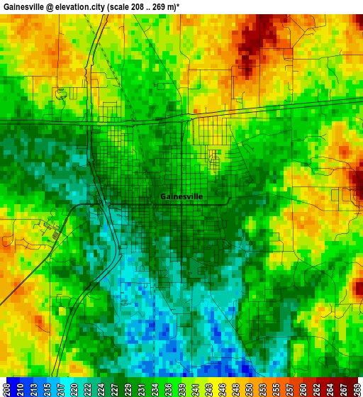
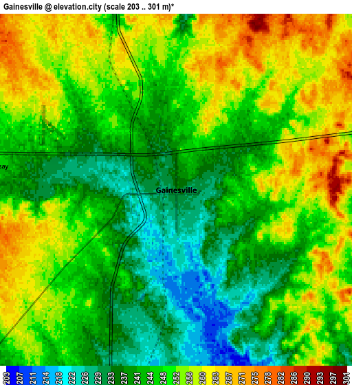
Below is the Elevation map of Gainesville, which displays elevation range with different colors. Scale of the first map is from 208 to 269 m (682 to 883 ft) with average elevation of 235.9 meters (=774 ft) [note 1]
These maps also provides idea of topography and contour of this city, they are displayed at different zoom levels. More info about maps, scale and edge coordinates you can find below images.
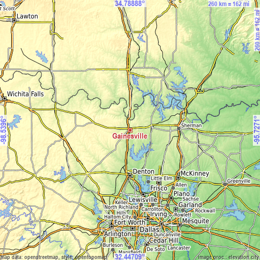
| \ | Map #1 | Map #2 | Topo.Map |
| Scale [m] | 208..269 m | 203..301 m | × |
| Scale [ft] | 682..883 ft | 666..988 ft | × |
| Average | 235.9 m = 774 ft | 247.5 m = 812 ft | × |
| Width | 8.14 km = 5.1 mi | 16.27 km = 10.1 mi | 260.4 km = 161.8 mi |
| Height | 8.14 km = 5.1 mi | 16.27 km = 10.1 mi | 260.4 km = 161.8 mi |
| ↑Max Latitude | 33.662524° | 33.699093° | 34.78888° |
| Latitude at center | 33.62594° | 33.62594° | 33.62594° |
| ↓Min Latitude | 33.58934° | 33.552725° | 32.44709° |
| ← Min Longitude | -97.177295° | -97.221241° | -98.5396° |
| Longitude center | -97.13335° | -97.13335° | -97.13335° |
| →Max Longitude | -97.089405° | -97.045459° | -95.7271° |
Nearby cities:
Cities around Gainesville sort by population:
• Sanger elevation 209 m
29.5 km,  187°
187°
• Pilot Point 223 m
30.1 km,  147°
147°
• Whitesboro 252 m
21.2 km,  80°
80°
• Aubrey 216 m
38.3 km,  159°
159°
• Marietta 262 m
34.6 km,  2°
2°
• Lake Kiowa 218 m
12.4 km,  116°
116°
• Collinsville 234 m
21.8 km,  109°
109°
• Muenster 308 m
22.7 km,  277°
277°
• Sherwood Shores 220 m
38.5 km,  49°
49°
• Lindsay 244 m
8.4 km, 277°
• Saint Jo 353 m
36.8 km, 282°
• Southmayd 226 m
33.7 km,  89°
89°
Multilingual:
 En español:
Gainesville elevación 233 m.
 En France:
Gainesville élévation 233 m.
 Auf Deutsch:
Gainesville höhe über dem Meeresspiegel ist 233 m.

Sources and notes:
- [note 1] Map square and city borders are not equal. Map elevation data is calculated only from area inside that square.
- [src 1] Elevation data from geonames database provided with same terms of usage.
- [src 2] The elevation map of Gainesville is generated using elevation data from NASA's 3 arcsec (90m) resolution SRTM data.
- [src 3] Base (background) map © OpenStreetMap contributors tiles are generated by Geofabrik and OpenTopoMap.
Copyright & License:
This Gainesville Elevation Map is licensed under CC BY-SA. You may reuse any part from this page, if you give a proper credit by linking to this URL:
 More info on terms of use page.