Comfort elevation
Comfort (Texas, Kendall County), United States elevation is 435 meters and Comfort elevation in feet is 1427 ft above sea level [src 1]. Comfort is a populated place (feature code) with elevation that is 156 meters (512 ft) bigger than average city elevation in United States.
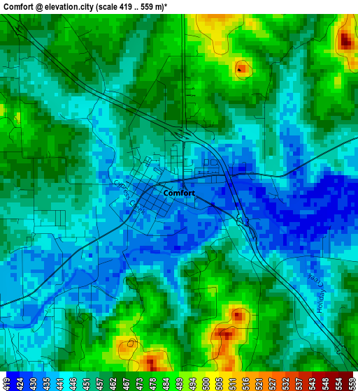
Below is the Elevation map of Comfort, which displays elevation range with different colors. Scale of the first map is from 419 to 559 m (1375 to 1834 ft) with average elevation of 456.9 meters (=1499 ft) [note 1]
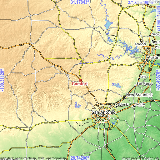
These maps also provides idea of topography and contour of this city, they are displayed at different zoom levels. More info about maps, scale and edge coordinates you can find below images.
| \ | Map #1 | Topo.Map |
| Scale [m] | 419..559 m | × |
| Scale [ft] | 1375..1834 ft | × |
| Average | 456.9 m = 1499 ft | × |
| Width | 8.47 km = 5.3 mi | 270.9 km = 168.3 mi |
| Height | 8.47 km = 5.3 mi | 270.9 km = 168.3 mi |
| ↑Max Latitude | 30.005773° | 31.17843° |
| Latitude at center | 29.96771° | 29.96771° |
| ↓Min Latitude | 29.929633° | 28.74206° |
| ← Min Longitude | -98.948975° | -100.31128° |
| Longitude center | -98.90503° | -98.90503° |
| →Max Longitude | -98.861085° | -97.49878° |
Nearby cities:
Cities around Comfort sort by population:
• Kerrville elevation 501 m
24.3 km,  291°
291°
• Boerne 431 m
25.5 km,  139°
139°
• Fredericksburg 519 m
34.3 km,  5°
5°
• Helotes 319 m
48.1 km,  154°
154°
• Fair Oaks Ranch 390 m
35.3 km,  134°
134°
• Lakehills 376 m
40.5 km,  185°
185°
• Scenic Oaks 411 m
36.1 km, 142°
• Medina 445 m
38 km,  239°
239°
• Cross Mountain 435 m
43 km, 146°
• Blanco 408 m
48.8 km,  72°
72°
• Ingram 528 m
34.5 km, 290°
• Bandera 382 m
31.4 km,  211°
211°
Multilingual:
 En español:
Comfort elevación 435 m.
 En France:
Comfort élévation 435 m.


Sources and notes:
- [note 1] Map square and city borders are not equal. Map elevation data is calculated only from area inside that square.
- [src 1] Elevation data from geonames database provided with same terms of usage.
- [src 2] The elevation map of Comfort is generated using elevation data from NASA's 3 arcsec (90m) resolution SRTM data.
- [src 3] Base (background) map © OpenStreetMap contributors tiles are generated by Geofabrik and OpenTopoMap.
Copyright & License:
This Comfort Elevation Map is licensed under CC BY-SA. You may reuse any part from this page, if you give a proper credit by linking to this URL:
 More info on terms of use page.