Blanco elevation
Blanco (Texas, Blanco County), United States elevation is 408 meters and Blanco elevation in feet is 1339 ft above sea level [src 1]. Blanco is a populated place (feature code) with elevation that is 129 meters (423 ft) bigger than average city elevation in United States.
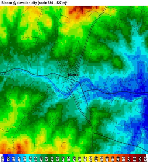
Below is the Elevation map of Blanco, which displays elevation range with different colors. Scale of the first map is from 384 to 527 m (1260 to 1729 ft) with average elevation of 431.9 meters (=1417 ft) [note 1]
These maps also provides idea of topography and contour of this city, they are displayed at different zoom levels. More info about maps, scale and edge coordinates you can find below images.
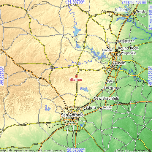
| \ | Map #1 | Topo.Map |
| Scale [m] | 384..527 m | × |
| Scale [ft] | 1260..1729 ft | × |
| Average | 431.9 m = 1417 ft | × |
| Width | 8.45 km = 5.3 mi | 270.5 km = 168.1 mi |
| Height | 8.45 km = 5.3 mi | 270.5 km = 168.1 mi |
| ↑Max Latitude | 30.136003° | 31.30709° |
| Latitude at center | 30.09799° | 30.09799° |
| ↓Min Latitude | 30.059963° | 28.87392° |
| ← Min Longitude | -98.465355° | -99.82766° |
| Longitude center | -98.42141° | -98.42141° |
| →Max Longitude | -98.377465° | -97.01516° |
Nearby cities:
Cities around Blanco sort by population:
• Canyon Lake elevation 296 m
29.1 km,  148°
148°
• Boerne 431 m
45.1 km,  221°
221°
• Timberwood Park 381 m
44 km,  187°
187°
• Fredericksburg 519 m
47.6 km,  294°
294°
• Fair Oaks Ranch 390 m
44.6 km,  208°
208°
• Scenic Oaks 411 m
49.5 km, 209°
• Bulverde 341 m
39.5 km,  184°
184°
• Wimberley 267 m
33 km,  109°
109°
• Dripping Springs 355 m
33.8 km,  72°
72°
• Comfort 435 m
48.8 km,  252°
252°
• Johnson City 369 m
19.9 km,  2°
2°
• Woodcreek 301 m
30.8 km,  104°
104°
Multilingual:
 En español:
Blanco elevación 408 m.
 En France:
Blanco élévation 408 m.


Sources and notes:
- [note 1] Map square and city borders are not equal. Map elevation data is calculated only from area inside that square.
- [src 1] Elevation data from geonames database provided with same terms of usage.
- [src 2] The elevation map of Blanco is generated using elevation data from NASA's 3 arcsec (90m) resolution SRTM data.
- [src 3] Base (background) map © OpenStreetMap contributors tiles are generated by Geofabrik and OpenTopoMap.
Copyright & License:
This Blanco Elevation Map is licensed under CC BY-SA. You may reuse any part from this page, if you give a proper credit by linking to this URL:
 More info on terms of use page.