Tiptonville elevation
Tiptonville (Tennessee, Lake County), United States elevation is 93 meters and Tiptonville elevation in feet is 305 ft above sea level [src 1]. Tiptonville is a seat of a second-order administrative division (feature code) with elevation that is 186 meters (610 ft) smaller than average city elevation in United States.
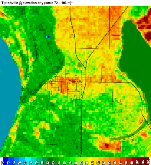
Below is the Elevation map of Tiptonville, which displays elevation range with different colors. Scale of the first map is from 72 to 103 m (236 to 338 ft) with average elevation of 87.3 meters (=286 ft) [note 1]
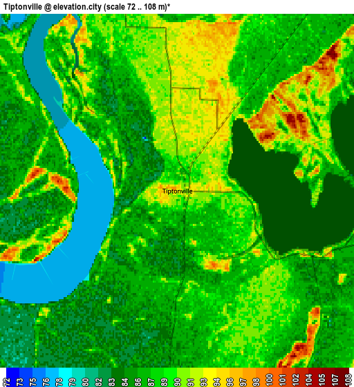
These maps also provides idea of topography and contour of this city, they are displayed at different zoom levels. More info about maps, scale and edge coordinates you can find below images.
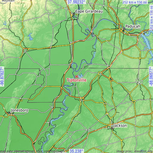
| \ | Map #1 | Map #2 | Topo.Map |
| Scale [m] | 72..103 m | 72..108 m | × |
| Scale [ft] | 236..338 ft | 236..354 ft | × |
| Average | 87.3 m = 286 ft | 87 m = 285 ft | × |
| Width | 7.87 km = 4.9 mi | 15.74 km = 9.8 mi | 251.8 km = 156.5 mi |
| Height | 7.87 km = 4.9 mi | 15.74 km = 9.8 mi | 251.8 km = 156.5 mi |
| ↑Max Latitude | 36.413773° | 36.44913° | 37.50232° |
| Latitude at center | 36.3784° | 36.3784° | 36.3784° |
| ↓Min Latitude | 36.343011° | 36.307606° | 35.238° |
| ← Min Longitude | -89.515965° | -89.559911° | -90.87827° |
| Longitude center | -89.47202° | -89.47202° | -89.47202° |
| →Max Longitude | -89.428075° | -89.384129° | -88.06577° |
Nearby cities:
Cities around Tiptonville sort by population:
• Union City elevation 105 m
37.5 km,  82°
82°
• Caruthersville 85 m
26.4 km,  218°
218°
• Newbern 116 m
35 km,  147°
147°
• Portageville 84 m
21 km,  284°
284°
• New Madrid 91 m
23.7 km,  347°
347°
• Hayti 82 m
29.6 km,  237°
237°
• Hickman 144 m
33.4 km,  50°
50°
• Ridgely 84 m
12.9 km,  186°
186°
• Englewood 135 m
28.4 km,  92°
92°
• Troy 115 m
27.9 km,  99°
99°
• Lilbourn 86 m
27 km,  331°
331°
• Obion 87 m
28.4 km,  117°
117°
Multilingual:
 En español:
Tiptonville elevación 93 m.
 En France:
Tiptonville élévation 93 m.
 Auf Deutsch:
Tiptonville höhe über dem Meeresspiegel ist 93 m.

Sources and notes:
- [note 1] Map square and city borders are not equal. Map elevation data is calculated only from area inside that square.
- [src 1] Elevation data from geonames database provided with same terms of usage.
- [src 2] The elevation map of Tiptonville is generated using elevation data from NASA's 3 arcsec (90m) resolution SRTM data.
- [src 3] Base (background) map © OpenStreetMap contributors tiles are generated by Geofabrik and OpenTopoMap.
Copyright & License:
This Tiptonville Elevation Map is licensed under CC BY-SA. You may reuse any part from this page, if you give a proper credit by linking to this URL:
 More info on terms of use page.