Sewanee elevation
Sewanee (Tennessee, Franklin County), United States elevation is 591 meters and Sewanee elevation in feet is 1939 ft above sea level [src 1]. Sewanee is a populated place (feature code) with elevation that is 312 meters (1024 ft) bigger than average city elevation in United States.
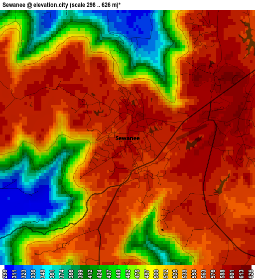
Below is the Elevation map of Sewanee, which displays elevation range with different colors. Scale of the first map is from 298 to 626 m (978 to 2054 ft) with average elevation of 522.4 meters (=1714 ft) [note 1]
These maps also provides idea of topography and contour of this city, they are displayed at different zoom levels. More info about maps, scale and edge coordinates you can find below images.
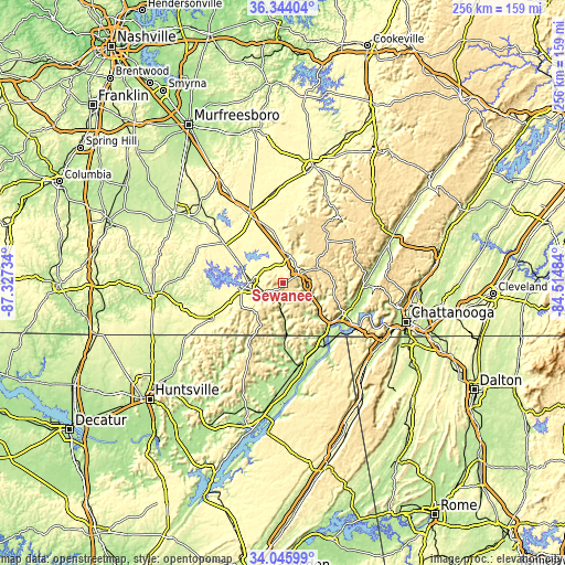
| \ | Map #1 | Topo.Map |
| Scale [m] | 298..626 m | × |
| Scale [ft] | 978..2054 ft | × |
| Average | 522.4 m = 1714 ft | × |
| Width | 7.99 km = 5 mi | 255.5 km = 158.8 mi |
| Height | 7.99 km = 5 mi | 255.5 km = 158.8 mi |
| ↑Max Latitude | 35.23904° | 36.34404° |
| Latitude at center | 35.20314° | 35.20314° |
| ↓Min Latitude | 35.167224° | 34.04599° |
| ← Min Longitude | -85.965035° | -87.32734° |
| Longitude center | -85.92109° | -85.92109° |
| →Max Longitude | -85.877145° | -84.51484° |
Nearby cities:
Cities around Sewanee sort by population:
• Tullahoma elevation 326 m
31.6 km,  304°
304°
• Winchester 298 m
17.5 km,  263°
263°
• Jasper 189 m
30.4 km,  118°
118°
• South Pittsburg 191 m
29 km,  137°
137°
• Decherd 291 m
14.4 km,  272°
272°
• Estill Springs 288 m
20.2 km,  291°
291°
• Cowan 295 m
9.2 km,  242°
242°
• Tracy City 558 m
18 km,  69°
69°
• Kimball 205 m
28.5 km,  127°
127°
• Monteagle 587 m
8.5 km,  60°
60°
• New Hope 222 m
32.5 km, 132°
• Altamont 564 m
30.9 km,  35°
35°
Multilingual:
 En español:
Sewanee elevación 591 m.
 En France:
Sewanee élévation 591 m.


Sources and notes:
- [note 1] Map square and city borders are not equal. Map elevation data is calculated only from area inside that square.
- [src 1] Elevation data from geonames database provided with same terms of usage.
- [src 2] The elevation map of Sewanee is generated using elevation data from NASA's 3 arcsec (90m) resolution SRTM data.
- [src 3] Base (background) map © OpenStreetMap contributors tiles are generated by Geofabrik and OpenTopoMap.
Copyright & License:
This Sewanee Elevation Map is licensed under CC BY-SA. You may reuse any part from this page, if you give a proper credit by linking to this URL:
 More info on terms of use page.