Jasper elevation
Jasper (Tennessee, Marion County), United States elevation is 189 meters and Jasper elevation in feet is 620 ft above sea level [src 1]. Jasper is a seat of a second-order administrative division (feature code) with elevation that is 90 meters (295 ft) smaller than average city elevation in United States.
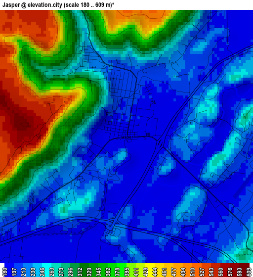
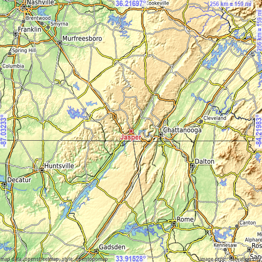
Below is the Elevation map of Jasper, which displays elevation range with different colors. Scale of the first map is from 180 to 609 m (591 to 1998 ft) with average elevation of 268.3 meters (=880 ft) [note 1]
These maps also provides idea of topography and contour of this city, they are displayed at different zoom levels. More info about maps, scale and edge coordinates you can find below images.
| \ | Map #1 | Topo.Map |
| Scale [m] | 180..609 m | × |
| Scale [ft] | 591..1998 ft | × |
| Average | 268.3 m = 880 ft | × |
| Width | 8 km = 5 mi | 255.9 km = 159 mi |
| Height | 8 km = 5 mi | 255.9 km = 159 mi |
| ↑Max Latitude | 35.110197° | 36.21697° |
| Latitude at center | 35.07424° | 35.07424° |
| ↓Min Latitude | 35.038267° | 33.91528° |
| ← Min Longitude | -85.670025° | -87.03233° |
| Longitude center | -85.62608° | -85.62608° |
| →Max Longitude | -85.582135° | -84.21983° |
Nearby cities:
Cities around Jasper sort by population:
• Signal Mountain elevation 521 m
26.2 km,  78°
78°
• South Pittsburg 191 m
9.9 km,  225°
225°
• Bridgeport 203 m
16.2 km,  209°
209°
• Trenton 227 m
24.9 km,  154°
154°
• Lookout Mountain 566 m
26.7 km,  109°
109°
• Whitwell 209 m
17.2 km,  34°
34°
• Lookout Mountain 551 m
26.7 km, 113°
• Tracy City 558 m
23 km,  334°
334°
• Kimball 205 m
5.1 km, 234°
• Powells Crossroads 208 m
18.1 km,  44°
44°
• Monteagle 587 m
26.8 km,  313°
313°
• New Hope 222 m
8.2 km,  200°
200°
Multilingual:
 En español:
Jasper elevación 189 m.
 En France:
Jasper élévation 189 m.


Sources and notes:
- [note 1] Map square and city borders are not equal. Map elevation data is calculated only from area inside that square.
- [src 1] Elevation data from geonames database provided with same terms of usage.
- [src 2] The elevation map of Jasper is generated using elevation data from NASA's 3 arcsec (90m) resolution SRTM data.
- [src 3] Base (background) map © OpenStreetMap contributors tiles are generated by Geofabrik and OpenTopoMap.
Copyright & License:
This Jasper Elevation Map is licensed under CC BY-SA. You may reuse any part from this page, if you give a proper credit by linking to this URL:
 More info on terms of use page.