Selmer elevation
Selmer (Tennessee, McNairy County), United States elevation is 139 meters and Selmer elevation in feet is 456 ft above sea level [src 1]. Selmer is a seat of a second-order administrative division (feature code) with elevation that is 140 meters (459 ft) smaller than average city elevation in United States.
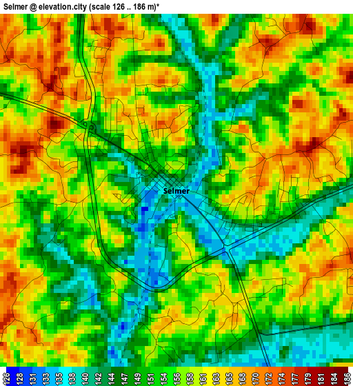
Below is the Elevation map of Selmer, which displays elevation range with different colors. Scale of the first map is from 126 to 186 m (413 to 610 ft) with average elevation of 155.2 meters (=509 ft) [note 1]
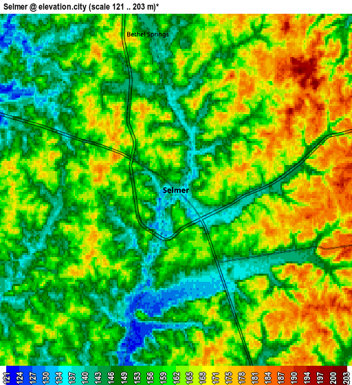
These maps also provides idea of topography and contour of this city, they are displayed at different zoom levels. More info about maps, scale and edge coordinates you can find below images.
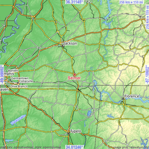
| \ | Map #1 | Map #2 | Topo.Map |
| Scale [m] | 126..186 m | 121..203 m | × |
| Scale [ft] | 413..610 ft | 397..666 ft | × |
| Average | 155.2 m = 509 ft | 158.1 m = 519 ft | × |
| Width | 7.99 km = 5 mi | 15.98 km = 9.9 mi | 255.6 km = 158.8 mi |
| Height | 7.99 km = 5 mi | 15.98 km = 9.9 mi | 255.6 km = 158.8 mi |
| ↑Max Latitude | 35.205995° | 35.241894° | 36.31145° |
| Latitude at center | 35.17008° | 35.17008° | 35.17008° |
| ↓Min Latitude | 35.134149° | 35.098202° | 34.01246° |
| ← Min Longitude | -88.636215° | -88.680161° | -89.99852° |
| Longitude center | -88.59227° | -88.59227° | -88.59227° |
| →Max Longitude | -88.548325° | -88.504379° | -87.18602° |
Nearby cities:
Cities around Selmer sort by population:
• Jackson elevation 126 m
53.3 km,  337°
337°
• Corinth 133 m
27 km,  166°
166°
• Lexington 161 m
56.4 km,  18°
18°
• Savannah 135 m
31.8 km,  78°
78°
• Henderson 137 m
30.3 km,  351°
351°
• Bolivar 136 m
37.2 km,  284°
284°
• Whiteville 150 m
53.5 km,  288°
288°
• Iuka 176 m
54.1 km,  137°
137°
• Adamsville 160 m
19.7 km,  68°
68°
• Farmington 158 m
29.6 km,  154°
154°
• Crump 140 m
25.6 km, 77°
• Olivet 141 m
36 km, 82°
Multilingual:
 En español:
Selmer elevación 139 m.
 En France:
Selmer élévation 139 m.


Sources and notes:
- [note 1] Map square and city borders are not equal. Map elevation data is calculated only from area inside that square.
- [src 1] Elevation data from geonames database provided with same terms of usage.
- [src 2] The elevation map of Selmer is generated using elevation data from NASA's 3 arcsec (90m) resolution SRTM data.
- [src 3] Base (background) map © OpenStreetMap contributors tiles are generated by Geofabrik and OpenTopoMap.
Copyright & License:
This Selmer Elevation Map is licensed under CC BY-SA. You may reuse any part from this page, if you give a proper credit by linking to this URL:
 More info on terms of use page.