Roan Mountain elevation
Roan Mountain (Tennessee, Carter County), United States elevation is 786 meters and Roan Mountain elevation in feet is 2579 ft above sea level [src 1]. Roan Mountain is a populated place (feature code) with elevation that is 507 meters (1663 ft) bigger than average city elevation in United States.
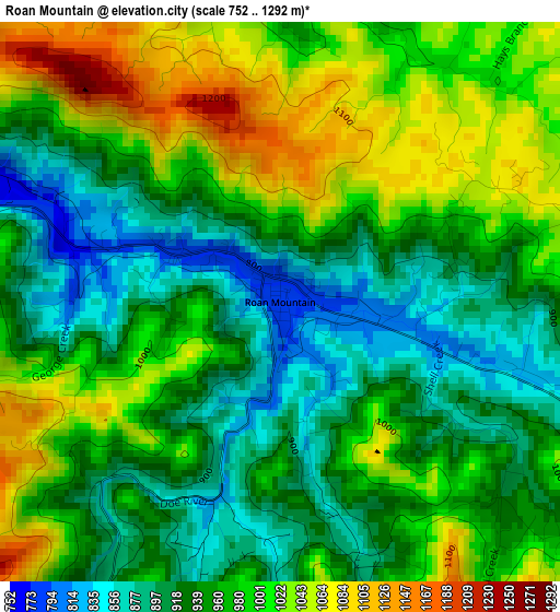
Below is the Elevation map of Roan Mountain, which displays elevation range with different colors. Scale of the first map is from 752 to 1292 m (2467 to 4239 ft) with average elevation of 966.1 meters (=3170 ft) [note 1]
These maps also provides idea of topography and contour of this city, they are displayed at different zoom levels. More info about maps, scale and edge coordinates you can find below images.
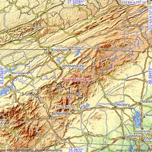
| \ | Map #1 | Topo.Map |
| Scale [m] | 752..1292 m | × |
| Scale [ft] | 2467..4239 ft | × |
| Average | 966.1 m = 3170 ft | × |
| Width | 7.89 km = 4.9 mi | 252.4 km = 156.8 mi |
| Height | 7.89 km = 4.9 mi | 252.4 km = 156.8 mi |
| ↑Max Latitude | 36.231686° | 37.32281° |
| Latitude at center | 36.19623° | 36.19623° |
| ↓Min Latitude | 36.160758° | 35.0532° |
| ← Min Longitude | -82.114345° | -83.47665° |
| Longitude center | -82.0704° | -82.0704° |
| →Max Longitude | -82.026455° | -80.66415° |
Nearby cities:
Cities around Roan Mountain sort by population:
• Johnson City elevation 500 m
28.5 km,  297°
297°
• Elizabethton 467 m
21.1 km,  323°
323°
• Erwin 514 m
31.6 km,  259°
259°
• Unicoi 591 m
25.1 km,  269°
269°
• Pine Crest 517 m
25 km, 297°
• Central 506 m
24.4 km,  306°
306°
• Spruce Pine 779 m
31.2 km,  179°
179°
• Hunter 479 m
21.1 km,  337°
337°
• Foscoe 924 m
27.6 km,  97°
97°
• Banner Elk 1130 m
18.2 km, 101°
• Newland 1101 m
17.7 km,  133°
133°
• Bakersville 760 m
21.6 km,  201°
201°
Multilingual:
 En español:
Roan Mountain elevación 786 m.
 En France:
Roan Mountain élévation 786 m.
 Auf Deutsch:
Roan Mountain höhe über dem Meeresspiegel ist 786 m.

Sources and notes:
- [note 1] Map square and city borders are not equal. Map elevation data is calculated only from area inside that square.
- [src 1] Elevation data from geonames database provided with same terms of usage.
- [src 2] The elevation map of Roan Mountain is generated using elevation data from NASA's 3 arcsec (90m) resolution SRTM data.
- [src 3] Base (background) map © OpenStreetMap contributors tiles are generated by Geofabrik and OpenTopoMap.
Copyright & License:
This Roan Mountain Elevation Map is licensed under CC BY-SA. You may reuse any part from this page, if you give a proper credit by linking to this URL:
 More info on terms of use page.