Bartlett elevation
Bartlett (Tennessee, Shelby County), United States elevation is 87 meters and Bartlett elevation in feet is 285 ft above sea level [src 1]. Bartlett is a populated place (feature code) with elevation that is 192 meters (630 ft) smaller than average city elevation in United States.
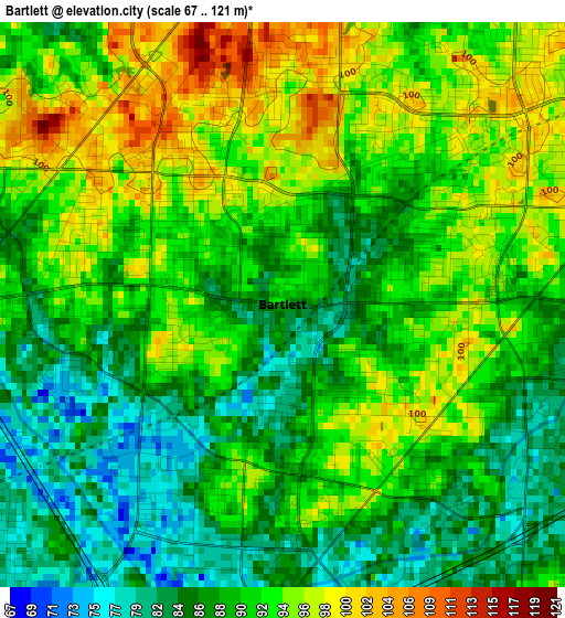
Below is the Elevation map of Bartlett, which displays elevation range with different colors. Scale of the first map is from 67 to 121 m (220 to 397 ft) with average elevation of 90.5 meters (=297 ft) [note 1]
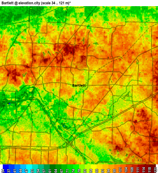
These maps also provides idea of topography and contour of this city, they are displayed at different zoom levels. More info about maps, scale and edge coordinates you can find below images.
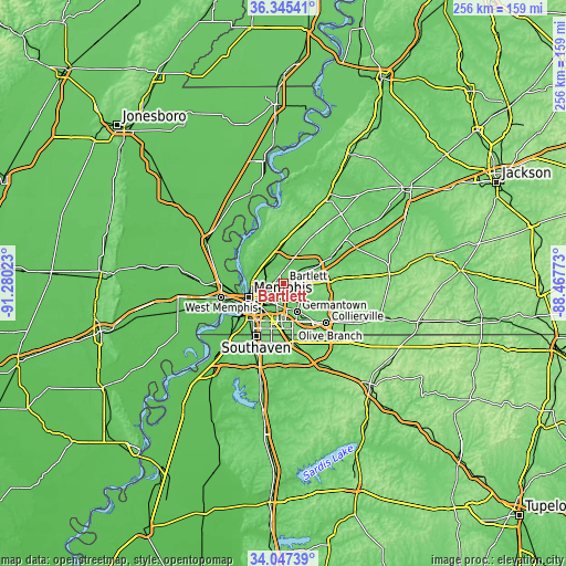
| \ | Map #1 | Map #2 | Topo.Map |
| Scale [m] | 67..121 m | 34..121 m | × |
| Scale [ft] | 220..397 ft | 112..397 ft | × |
| Average | 90.5 m = 297 ft | 88.4 m = 290 ft | × |
| Width | 7.99 km = 5 mi | 15.97 km = 9.9 mi | 255.5 km = 158.8 mi |
| Height | 7.99 km = 5 mi | 15.97 km = 9.9 mi | 255.5 km = 158.8 mi |
| ↑Max Latitude | 35.24043° | 35.276314° | 36.34541° |
| Latitude at center | 35.20453° | 35.20453° | 35.20453° |
| ↓Min Latitude | 35.168614° | 35.132683° | 34.04739° |
| ← Min Longitude | -89.917925° | -89.961871° | -91.28023° |
| Longitude center | -89.87398° | -89.87398° | -89.87398° |
| →Max Longitude | -89.830035° | -89.786089° | -88.46773° |
Nearby cities:
Cities around Bartlett sort by population:
• Memphis elevation 84 m
17 km,  248°
248°
• New South Memphis 79 m
21.2 km,  231°
231°
• Southaven 95 m
27.1 km,  207°
207°
• Collierville 117 m
26.3 km,  133°
133°
• Germantown 120 m
14.3 km,  156°
156°
• Olive Branch 119 m
27.3 km,  171°
171°
• Lakeland 129 m
12.5 km,  76°
76°
• Arlington 87 m
21.8 km,  62°
62°
• Millington 81 m
15.4 km,  352°
352°
• Atoka 131 m
27.7 km,  18°
18°
• Munford 135 m
27.7 km,  11°
11°
• Hickory Withe 126 m
26.3 km, 80°
Multilingual:
 En español:
Bartlett elevación 87 m.
 En France:
Bartlett élévation 87 m.


Sources and notes:
- [note 1] Map square and city borders are not equal. Map elevation data is calculated only from area inside that square.
- [src 1] Elevation data from geonames database provided with same terms of usage.
- [src 2] The elevation map of Bartlett is generated using elevation data from NASA's 3 arcsec (90m) resolution SRTM data.
- [src 3] Base (background) map © OpenStreetMap contributors tiles are generated by Geofabrik and OpenTopoMap.
Copyright & License:
This Bartlett Elevation Map is licensed under CC BY-SA. You may reuse any part from this page, if you give a proper credit by linking to this URL:
 More info on terms of use page.