Winnsboro Mills elevation
Winnsboro Mills (South Carolina, Fairfield County), United States elevation is 169 meters and Winnsboro Mills elevation in feet is 554 ft above sea level [src 1]. Winnsboro Mills is a populated place (feature code) with elevation that is 110 meters (361 ft) smaller than average city elevation in United States.
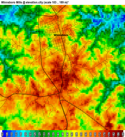
Below is the Elevation map of Winnsboro Mills, which displays elevation range with different colors. Scale of the first map is from 103 to 189 m (338 to 620 ft) with average elevation of 152.5 meters (=500 ft) [note 1]
These maps also provides idea of topography and contour of this city, they are displayed at different zoom levels. More info about maps, scale and edge coordinates you can find below images.
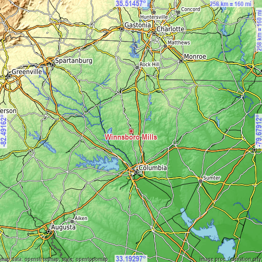
| \ | Map #1 | Topo.Map |
| Scale [m] | 103..189 m | × |
| Scale [ft] | 338..620 ft | × |
| Average | 152.5 m = 500 ft | × |
| Width | 8.07 km = 5 mi | 258.1 km = 160.4 mi |
| Height | 8.07 km = 5 mi | 258.1 km = 160.4 mi |
| ↑Max Latitude | 34.398079° | 35.51457° |
| Latitude at center | 34.36181° | 34.36181° |
| ↓Min Latitude | 34.325526° | 33.19297° |
| ← Min Longitude | -81.129315° | -82.49162° |
| Longitude center | -81.08537° | -81.08537° |
| →Max Longitude | -81.041425° | -79.67912° |
Nearby cities:
Cities around Winnsboro Mills sort by population:
• Saint Andrews elevation 92 m
35.4 km,  186°
186°
• Seven Oaks 73 m
35.3 km, 189°
• Dentsville 69 m
35.1 km,  160°
160°
• Irmo 107 m
32 km,  196°
196°
• Forest Acres 76 m
39.1 km,  167°
167°
• Woodfield 102 m
36.5 km, 157°
• Lake Murray of Richland 119 m
31.5 km,  211°
211°
• Winnsboro 164 m
2.1 km,  357°
357°
• Blythewood 154 m
19.3 km,  148°
148°
• Great Falls 141 m
29.1 km,  35°
35°
• Chapin 139 m
32.6 km,  228°
228°
• Elgin 123 m
34.1 km,  128°
128°
Multilingual:
 En español:
Winnsboro Mills elevación 169 m.
 En France:
Winnsboro Mills élévation 169 m.
 Auf Deutsch:
Winnsboro Mills höhe über dem Meeresspiegel ist 169 m.

Sources and notes:
- [note 1] Map square and city borders are not equal. Map elevation data is calculated only from area inside that square.
- [src 1] Elevation data from geonames database provided with same terms of usage.
- [src 2] The elevation map of Winnsboro Mills is generated using elevation data from NASA's 3 arcsec (90m) resolution SRTM data.
- [src 3] Base (background) map © OpenStreetMap contributors tiles are generated by Geofabrik and OpenTopoMap.
Copyright & License:
This Winnsboro Mills Elevation Map is licensed under CC BY-SA. You may reuse any part from this page, if you give a proper credit by linking to this URL:
 More info on terms of use page.