Timmonsville elevation
Timmonsville (South Carolina, Florence County), United States elevation is 45 meters and Timmonsville elevation in feet is 148 ft above sea level [src 1]. Timmonsville is a populated place (feature code) with elevation that is 234 meters (768 ft) smaller than average city elevation in United States.
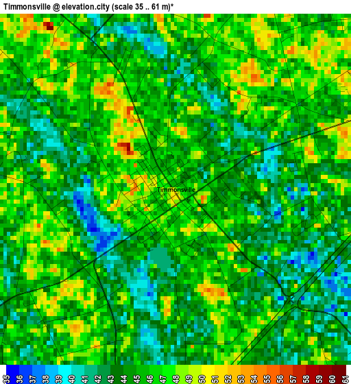
Below is the Elevation map of Timmonsville, which displays elevation range with different colors. Scale of the first map is from 35 to 61 m (115 to 200 ft) with average elevation of 44.9 meters (=147 ft) [note 1]
These maps also provides idea of topography and contour of this city, they are displayed at different zoom levels. More info about maps, scale and edge coordinates you can find below images.
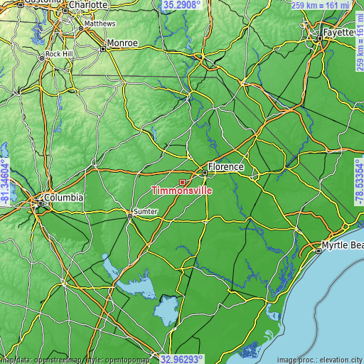
| \ | Map #1 | Topo.Map |
| Scale [m] | 35..61 m | × |
| Scale [ft] | 115..200 ft | × |
| Average | 44.9 m = 147 ft | × |
| Width | 8.09 km = 5 mi | 258.8 km = 160.8 mi |
| Height | 8.09 km = 5 mi | 258.8 km = 160.8 mi |
| ↑Max Latitude | 34.171247° | 35.2908° |
| Latitude at center | 34.13488° | 34.13488° |
| ↓Min Latitude | 34.098498° | 32.96293° |
| ← Min Longitude | -79.983735° | -81.34604° |
| Longitude center | -79.93979° | -79.93979° |
| →Max Longitude | -79.895845° | -78.53354° |
Nearby cities:
Cities around Timmonsville sort by population:
• Sumter elevation 54 m
44 km,  237°
237°
• Florence 45 m
17.6 km,  67°
67°
• Hartsville 66 m
29.3 km,  335°
335°
• Lake City 22 m
33.9 km,  149°
149°
• Darlington 47 m
19.3 km,  17°
17°
• Bishopville 69 m
29.9 km,  288°
288°
• North Hartsville 63 m
31.2 km, 337°
• Dalzell 67 m
47 km,  253°
253°
• Lakewood 54 m
49.6 km,  229°
229°
• South Sumter 53 m
45.3 km, 235°
• East Sumter 45 m
40.3 km, 234°
• Pamplico 20 m
37.4 km,  114°
114°
Multilingual:
 En español:
Timmonsville elevación 45 m.
 En France:
Timmonsville élévation 45 m.
 Auf Deutsch:
Timmonsville höhe über dem Meeresspiegel ist 45 m.

Sources and notes:
- [note 1] Map square and city borders are not equal. Map elevation data is calculated only from area inside that square.
- [src 1] Elevation data from geonames database provided with same terms of usage.
- [src 2] The elevation map of Timmonsville is generated using elevation data from NASA's 3 arcsec (90m) resolution SRTM data.
- [src 3] Base (background) map © OpenStreetMap contributors tiles are generated by Geofabrik and OpenTopoMap.
Copyright & License:
This Timmonsville Elevation Map is licensed under CC BY-SA. You may reuse any part from this page, if you give a proper credit by linking to this URL:
 More info on terms of use page.