Greer elevation
Greer (South Carolina, Greenville County), United States elevation is 312 meters and Greer elevation in feet is 1024 ft above sea level [src 1]. Greer is a populated place (feature code) with elevation that is 33 meters (108 ft) bigger than average city elevation in United States.
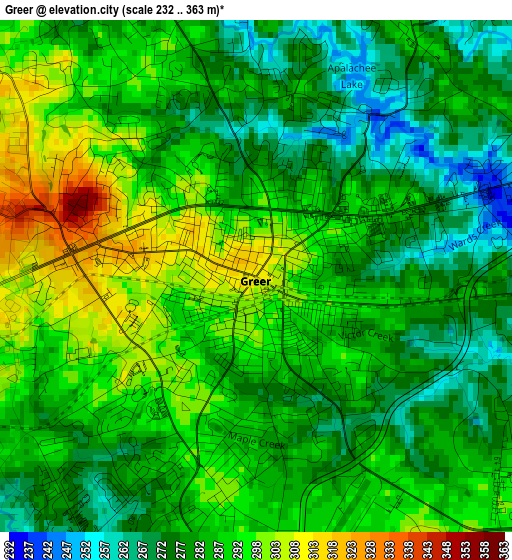
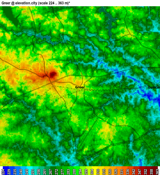
Below is the Elevation map of Greer, which displays elevation range with different colors. Scale of the first map is from 232 to 363 m (761 to 1191 ft) with average elevation of 285.9 meters (=938 ft) [note 1]
These maps also provides idea of topography and contour of this city, they are displayed at different zoom levels. More info about maps, scale and edge coordinates you can find below images.
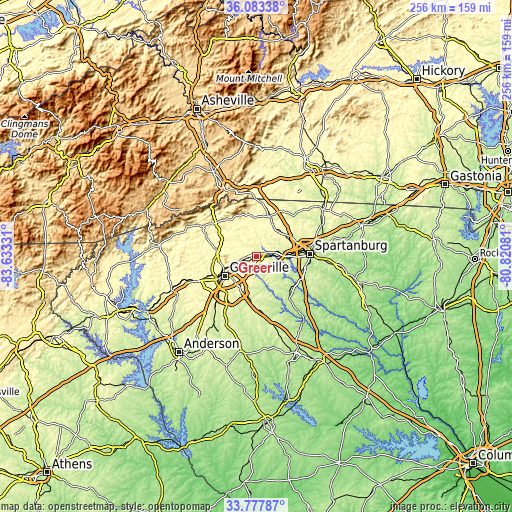
| \ | Map #1 | Map #2 | Topo.Map |
| Scale [m] | 232..363 m | 224..363 m | × |
| Scale [ft] | 761..1191 ft | 735..1191 ft | × |
| Average | 285.9 m = 938 ft | 280.4 m = 920 ft | × |
| Width | 8.01 km = 5 mi | 16.02 km = 10 mi | 256.3 km = 159.3 mi |
| Height | 8.01 km = 5 mi | 16.02 km = 10 mi | 256.3 km = 159.3 mi |
| ↑Max Latitude | 34.974747° | 35.010748° | 36.08338° |
| Latitude at center | 34.93873° | 34.93873° | 34.93873° |
| ↓Min Latitude | 34.902697° | 34.866649° | 33.77787° |
| ← Min Longitude | -82.271005° | -82.314951° | -83.63331° |
| Longitude center | -82.22706° | -82.22706° | -82.22706° |
| →Max Longitude | -82.183115° | -82.139169° | -80.82081° |
Nearby cities:
Cities around Greer sort by population:
• Greenville elevation 307 m
18 km,  237°
237°
• Mauldin 289 m
19.3 km,  203°
203°
• Taylors 284 m
6.6 km,  252°
252°
• Wade Hampton 313 m
10.4 km, 248°
• Five Forks 268 m
14.9 km,  180°
180°
• Sans Souci 310 m
19.2 km, 249°
• Lyman 260 m
9.2 km,  83°
83°
• Duncan 264 m
7.5 km,  90°
90°
• Wellford 267 m
11.1 km, 82°
• Inman 301 m
17.3 km,  46°
46°
• Tigerville 308 m
19.3 km,  318°
318°
• Inman Mills 282 m
16 km,  44°
44°
Multilingual:
 En español:
Greer elevación 312 m.
 En France:
Greer élévation 312 m.


Sources and notes:
- [note 1] Map square and city borders are not equal. Map elevation data is calculated only from area inside that square.
- [src 1] Elevation data from geonames database provided with same terms of usage.
- [src 2] The elevation map of Greer is generated using elevation data from NASA's 3 arcsec (90m) resolution SRTM data.
- [src 3] Base (background) map © OpenStreetMap contributors tiles are generated by Geofabrik and OpenTopoMap.
Copyright & License:
This Greer Elevation Map is licensed under CC BY-SA. You may reuse any part from this page, if you give a proper credit by linking to this URL:
 More info on terms of use page.