Caln elevation
Caln (Pennsylvania, Chester County), United States elevation is 99 meters and Caln elevation in feet is 325 ft above sea level [src 1]. Caln is a populated place (feature code) with elevation that is 180 meters (591 ft) smaller than average city elevation in United States.
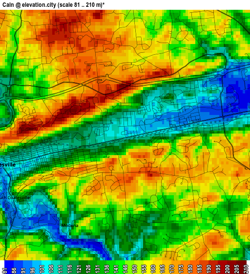
Below is the Elevation map of Caln, which displays elevation range with different colors. Scale of the first map is from 81 to 210 m (266 to 689 ft) with average elevation of 144.6 meters (=474 ft) [note 1]
These maps also provides idea of topography and contour of this city, they are displayed at different zoom levels. More info about maps, scale and edge coordinates you can find below images.
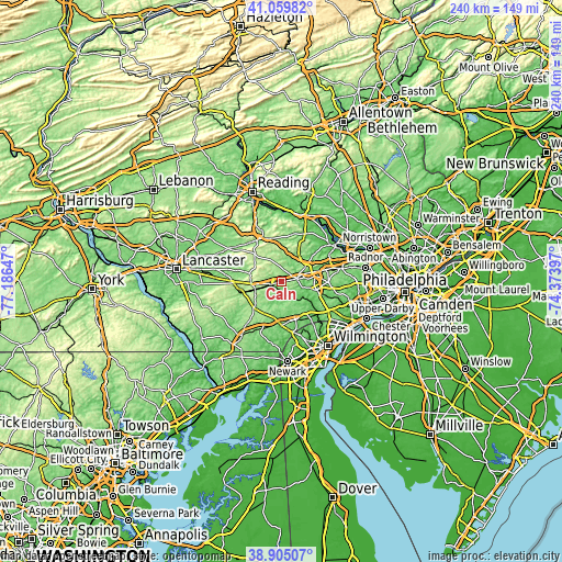
| \ | Map #1 | Topo.Map |
| Scale [m] | 81..210 m | × |
| Scale [ft] | 266..689 ft | × |
| Average | 144.6 m = 474 ft | × |
| Width | 7.49 km = 4.7 mi | 239.6 km = 148.9 mi |
| Height | 7.49 km = 4.7 mi | 239.6 km = 148.9 mi |
| ↑Max Latitude | 40.0246° | 41.05982° |
| Latitude at center | 39.99094° | 39.99094° |
| ↓Min Latitude | 39.957263° | 38.90507° |
| ← Min Longitude | -75.824165° | -77.18647° |
| Longitude center | -75.78022° | -75.78022° |
| →Max Longitude | -75.736275° | -74.37397° |
Nearby cities:
Cities around Caln sort by population:
• West Chester elevation 136 m
15 km,  102°
102°
• Coatesville 99 m
3.8 km,  256°
256°
• Downingtown 74 m
6.8 km,  75°
75°
• Lionville 168 m
12.4 km,  55°
55°
• Kennett Square 120 m
17.1 km,  159°
159°
• Exton 97 m
14.2 km,  72°
72°
• Parkesburg 165 m
12.4 km,  253°
253°
• Thorndale 115 m
3 km,  85°
85°
• Upland 166 m
11.6 km,  177°
177°
• Honey Brook 228 m
16 km,  315°
315°
• Eagleview 132 m
11.4 km,  48°
48°
• South Coatesville 109 m
3.9 km,  241°
241°
Multilingual:
 En español:
Caln elevación 99 m.
 En France:
Caln élévation 99 m.


Sources and notes:
- [note 1] Map square and city borders are not equal. Map elevation data is calculated only from area inside that square.
- [src 1] Elevation data from geonames database provided with same terms of usage.
- [src 2] The elevation map of Caln is generated using elevation data from NASA's 3 arcsec (90m) resolution SRTM data.
- [src 3] Base (background) map © OpenStreetMap contributors tiles are generated by Geofabrik and OpenTopoMap.
Copyright & License:
This Caln Elevation Map is licensed under CC BY-SA. You may reuse any part from this page, if you give a proper credit by linking to this URL:
 More info on terms of use page.