Slaughterville elevation
Slaughterville (Oklahoma, Cleveland County), United States elevation is 344 meters and Slaughterville elevation in feet is 1129 ft above sea level [src 1]. Slaughterville is a populated place (feature code) with elevation that is 65 meters (213 ft) bigger than average city elevation in United States.
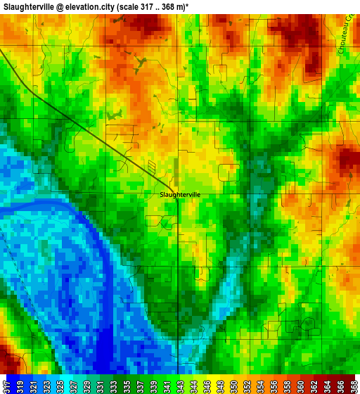
Below is the Elevation map of Slaughterville, which displays elevation range with different colors. Scale of the first map is from 317 to 368 m (1040 to 1207 ft) with average elevation of 340.4 meters (=1117 ft) [note 1]
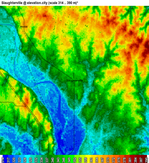
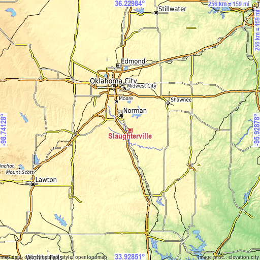
These maps also provides idea of topography and contour of this city, they are displayed at different zoom levels. More info about maps, scale and edge coordinates you can find below images.
| \ | Map #1 | Map #2 | Topo.Map |
| Scale [m] | 317..368 m | 314..390 m | × |
| Scale [ft] | 1040..1207 ft | 1030..1280 ft | × |
| Average | 340.4 m = 1117 ft | 345 m = 1132 ft | × |
| Width | 8 km = 5 mi | 15.99 km = 9.9 mi | 255.9 km = 159 mi |
| Height | 8 km = 5 mi | 15.99 km = 9.9 mi | 255.9 km = 159 mi |
| ↑Max Latitude | 35.123242° | 35.159177° | 36.22984° |
| Latitude at center | 35.08729° | 35.08729° | 35.08729° |
| ↓Min Latitude | 35.051323° | 35.015339° | 33.92851° |
| ← Min Longitude | -97.378975° | -97.422921° | -98.74128° |
| Longitude center | -97.33503° | -97.33503° | -97.33503° |
| →Max Longitude | -97.291085° | -97.247139° | -95.92878° |
Nearby cities:
Cities around Slaughterville sort by population:
• Norman elevation 361 m
17.8 km,  327°
327°
• Moore 385 m
31.2 km, 333°
• Newcastle 372 m
29.9 km,  306°
306°
• Blanchard 391 m
29.9 km,  280°
280°
• Noble 367 m
7.9 km,  316°
316°
• Purcell 341 m
8.5 km,  196°
196°
• Lindsay 302 m
37.2 km,  220°
220°
• Lexington 319 m
8.1 km,  180°
180°
• Goldsby 354 m
14.2 km,  294°
294°
• Pink 343 m
27.5 km,  45°
45°
• Maysville 291 m
30.7 km,  192°
192°
• Hall Park 366 m
17.9 km,  338°
338°
Multilingual:
 En español:
Slaughterville elevación 344 m.
 En France:
Slaughterville élévation 344 m.
 Auf Deutsch:
Slaughterville höhe über dem Meeresspiegel ist 344 m.

Sources and notes:
- [note 1] Map square and city borders are not equal. Map elevation data is calculated only from area inside that square.
- [src 1] Elevation data from geonames database provided with same terms of usage.
- [src 2] The elevation map of Slaughterville is generated using elevation data from NASA's 3 arcsec (90m) resolution SRTM data.
- [src 3] Base (background) map © OpenStreetMap contributors tiles are generated by Geofabrik and OpenTopoMap.
Copyright & License:
This Slaughterville Elevation Map is licensed under CC BY-SA. You may reuse any part from this page, if you give a proper credit by linking to this URL:
 More info on terms of use page.