Fairfax elevation
Fairfax (Oklahoma, Osage County), United States elevation is 262 meters and Fairfax elevation in feet is 860 ft above sea level [src 1]. Fairfax is a populated place (feature code) with elevation that is 17 meters (56 ft) smaller than average city elevation in United States.
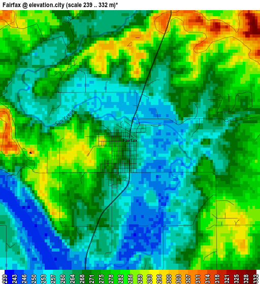
Below is the Elevation map of Fairfax, which displays elevation range with different colors. Scale of the first map is from 239 to 332 m (784 to 1089 ft) with average elevation of 270.7 meters (=888 ft) [note 1]
These maps also provides idea of topography and contour of this city, they are displayed at different zoom levels. More info about maps, scale and edge coordinates you can find below images.
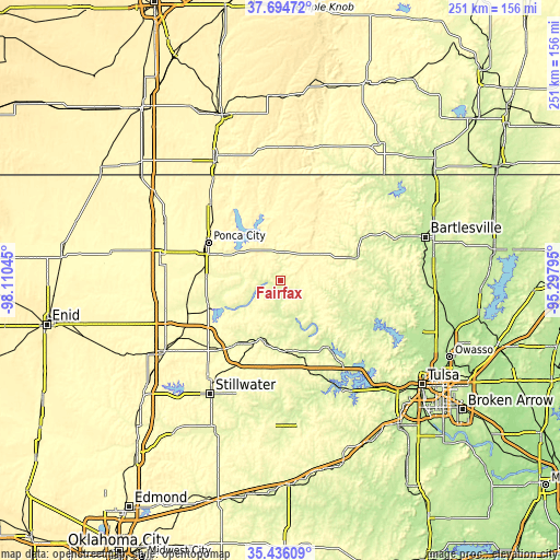
| \ | Map #1 | Topo.Map |
| Scale [m] | 239..332 m | × |
| Scale [ft] | 784..1089 ft | × |
| Average | 270.7 m = 888 ft | × |
| Width | 7.85 km = 4.9 mi | 251.1 km = 156 mi |
| Height | 7.85 km = 4.9 mi | 251.1 km = 156 mi |
| ↑Max Latitude | 36.608944° | 37.69472° |
| Latitude at center | 36.57366° | 36.57366° |
| ↓Min Latitude | 36.53836° | 35.43609° |
| ← Min Longitude | -96.748145° | -98.11045° |
| Longitude center | -96.7042° | -96.7042° |
| →Max Longitude | -96.660255° | -95.29795° |
Nearby cities:
Cities around Fairfax sort by population:
• Ponca City elevation 315 m
37.1 km,  293°
293°
• Blackwell 316 m
57.6 km,  296°
296°
• Pawhuska 255 m
34.4 km,  72°
72°
• Hominy 244 m
32.8 km,  122°
122°
• Cleveland 234 m
36.2 km,  143°
143°
• Tonkawa 306 m
55.3 km,  282°
282°
• Newkirk 357 m
46.3 km,  317°
317°
• Pawnee 270 m
27.7 km,  198°
198°
• McCord 328 m
32.2 km, 291°
• Yale 250 m
51.1 km,  179°
179°
• Barnsdall 230 m
48.5 km,  91°
91°
• Oilton 249 m
55.5 km,  168°
168°
Multilingual:
 En español:
Fairfax elevación 262 m.
 En France:
Fairfax élévation 262 m.


Sources and notes:
- [note 1] Map square and city borders are not equal. Map elevation data is calculated only from area inside that square.
- [src 1] Elevation data from geonames database provided with same terms of usage.
- [src 2] The elevation map of Fairfax is generated using elevation data from NASA's 3 arcsec (90m) resolution SRTM data.
- [src 3] Base (background) map © OpenStreetMap contributors tiles are generated by Geofabrik and OpenTopoMap.
Copyright & License:
This Fairfax Elevation Map is licensed under CC BY-SA. You may reuse any part from this page, if you give a proper credit by linking to this URL:
 More info on terms of use page.