Boley elevation
Boley (Oklahoma, Okfuskee County), United States elevation is 274 meters and Boley elevation in feet is 899 ft above sea level [src 1]. Boley is a populated place (feature code) with elevation that is 5 meters (16 ft) smaller than average city elevation in United States.
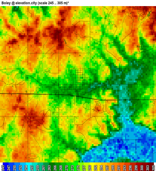
Below is the Elevation map of Boley, which displays elevation range with different colors. Scale of the first map is from 245 to 305 m (804 to 1001 ft) with average elevation of 277.5 meters (=910 ft) [note 1]
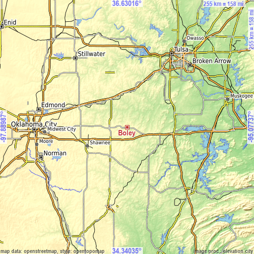
These maps also provides idea of topography and contour of this city, they are displayed at different zoom levels. More info about maps, scale and edge coordinates you can find below images.
| \ | Map #1 | Topo.Map |
| Scale [m] | 245..305 m | × |
| Scale [ft] | 804..1001 ft | × |
| Average | 277.5 m = 910 ft | × |
| Width | 7.96 km = 4.9 mi | 254.6 km = 158.2 mi |
| Height | 7.96 km = 4.9 mi | 254.6 km = 158.2 mi |
| ↑Max Latitude | 35.529182° | 36.63016° |
| Latitude at center | 35.49341° | 35.49341° |
| ↓Min Latitude | 35.457623° | 34.34035° |
| ← Min Longitude | -96.527565° | -97.88987° |
| Longitude center | -96.48362° | -96.48362° |
| →Max Longitude | -96.439675° | -95.07737° |
Nearby cities:
Cities around Boley sort by population:
• Shawnee elevation 326 m
44.1 km,  245°
245°
• Seminole 275 m
34.4 km,  209°
209°
• Henryetta 211 m
45.8 km,  97°
97°
• Bristow 251 m
38.4 km,  12°
12°
• Wewoka 250 m
37.2 km,  181°
181°
• Okemah 281 m
17.5 km,  112°
112°
• Chandler 289 m
42.7 km,  302°
302°
• Stroud 270 m
32.5 km,  330°
330°
• Prague 311 m
18.2 km,  267°
267°
• Wilson 211 m
40.7 km,  87°
87°
• Wetumka 239 m
35.9 km,  142°
142°
• Meeker 278 m
38 km, 271°
Multilingual:
 En español:
Boley elevación 274 m.
 En France:
Boley élévation 274 m.


Sources and notes:
- [note 1] Map square and city borders are not equal. Map elevation data is calculated only from area inside that square.
- [src 1] Elevation data from geonames database provided with same terms of usage.
- [src 2] The elevation map of Boley is generated using elevation data from NASA's 3 arcsec (90m) resolution SRTM data.
- [src 3] Base (background) map © OpenStreetMap contributors tiles are generated by Geofabrik and OpenTopoMap.
Copyright & License:
This Boley Elevation Map is licensed under CC BY-SA. You may reuse any part from this page, if you give a proper credit by linking to this URL:
 More info on terms of use page.