Peebles elevation
Peebles (Ohio, Adams County), United States elevation is 251 meters and Peebles elevation in feet is 823 ft above sea level [src 1]. Peebles is a populated place (feature code) with elevation that is 28 meters (92 ft) smaller than average city elevation in United States.
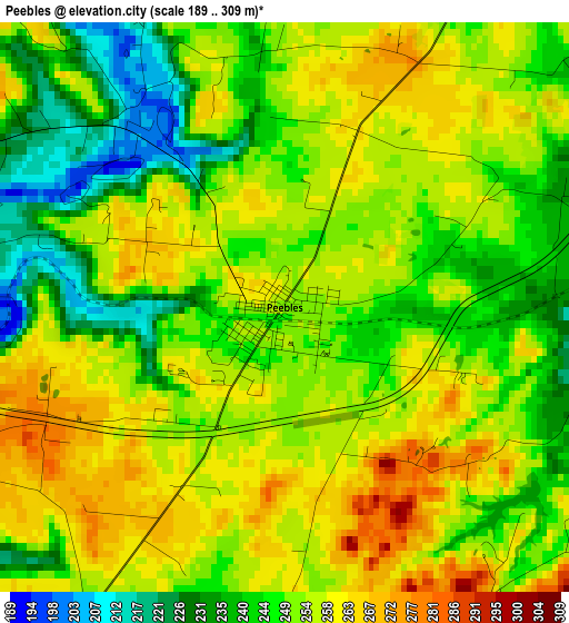
Below is the Elevation map of Peebles, which displays elevation range with different colors. Scale of the first map is from 189 to 309 m (620 to 1014 ft) with average elevation of 250.8 meters (=823 ft) [note 1]
These maps also provides idea of topography and contour of this city, they are displayed at different zoom levels. More info about maps, scale and edge coordinates you can find below images.
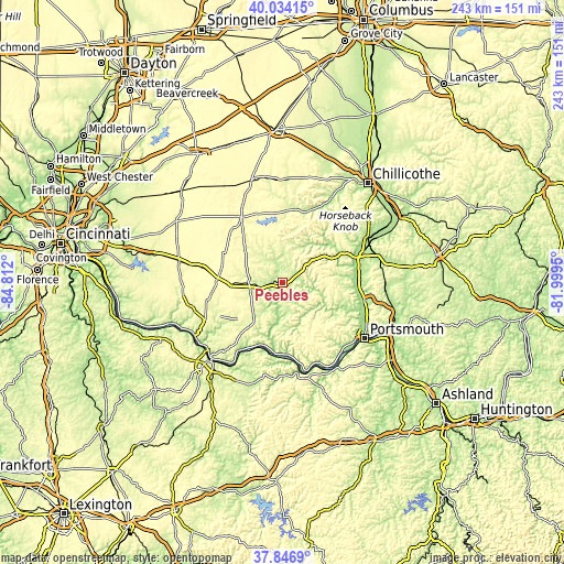
| \ | Map #1 | Topo.Map |
| Scale [m] | 189..309 m | × |
| Scale [ft] | 620..1014 ft | × |
| Average | 250.8 m = 823 ft | × |
| Width | 7.6 km = 4.7 mi | 243.2 km = 151.1 mi |
| Height | 7.6 km = 4.7 mi | 243.2 km = 151.1 mi |
| ↑Max Latitude | 38.983128° | 40.03415° |
| Latitude at center | 38.94896° | 38.94896° |
| ↓Min Latitude | 38.914775° | 37.8469° |
| ← Min Longitude | -83.449695° | -84.812° |
| Longitude center | -83.40575° | -83.40575° |
| →Max Longitude | -83.361805° | -81.9995° |
Nearby cities:
Cities around Peebles sort by population:
• Portsmouth elevation 164 m
42.8 km,  124°
124°
• Hillsboro 345 m
33.3 km,  327°
327°
• Georgetown 282 m
44.1 km,  257°
257°
• Waverly 178 m
41.3 km,  61°
61°
• West Union 288 m
21 km,  215°
215°
• West Portsmouth 189 m
38.9 km, 123°
• Lucasville 169 m
36.2 km,  102°
102°
• Piketon 175 m
36.3 km,  68°
68°
• Rosemount 187 m
41.1 km, 116°
• Manchester 155 m
33.9 km,  211°
211°
• Vanceburg 161 m
39.6 km,  169°
169°
• Winchester 296 m
21.2 km,  267°
267°
Multilingual:
 En español:
Peebles elevación 251 m.
 En France:
Peebles élévation 251 m.


Sources and notes:
- [note 1] Map square and city borders are not equal. Map elevation data is calculated only from area inside that square.
- [src 1] Elevation data from geonames database provided with same terms of usage.
- [src 2] The elevation map of Peebles is generated using elevation data from NASA's 3 arcsec (90m) resolution SRTM data.
- [src 3] Base (background) map © OpenStreetMap contributors tiles are generated by Geofabrik and OpenTopoMap.
Copyright & License:
This Peebles Elevation Map is licensed under CC BY-SA. You may reuse any part from this page, if you give a proper credit by linking to this URL:
 More info on terms of use page.