Nelsonville elevation
Nelsonville (Ohio, Athens County), United States elevation is 209 meters and Nelsonville elevation in feet is 686 ft above sea level [src 1]. Nelsonville is a populated place (feature code) with elevation that is 70 meters (230 ft) smaller than average city elevation in United States.
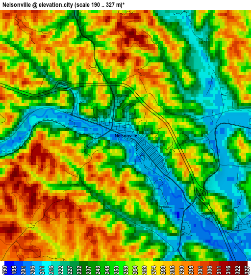
Below is the Elevation map of Nelsonville, which displays elevation range with different colors. Scale of the first map is from 190 to 327 m (623 to 1073 ft) with average elevation of 256.2 meters (=841 ft) [note 1]
These maps also provides idea of topography and contour of this city, they are displayed at different zoom levels. More info about maps, scale and edge coordinates you can find below images.
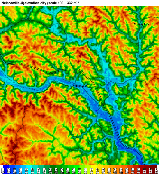
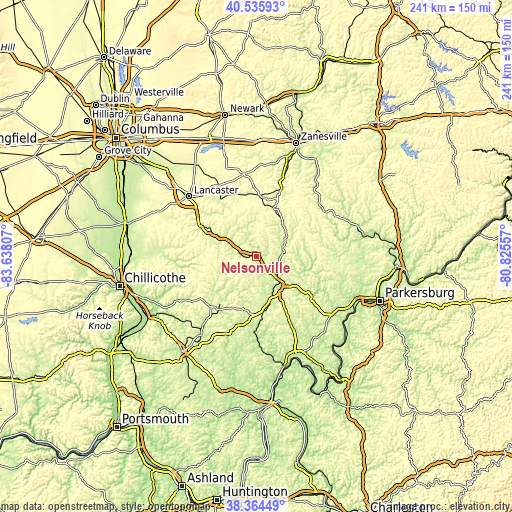
| \ | Map #1 | Map #2 | Topo.Map |
| Scale [m] | 190..327 m | 190..332 m | × |
| Scale [ft] | 623..1073 ft | 623..1089 ft | × |
| Average | 256.2 m = 841 ft | 263.4 m = 864 ft | × |
| Width | 7.55 km = 4.7 mi | 15.09 km = 9.4 mi | 241.4 km = 150 mi |
| Height | 7.55 km = 4.7 mi | 15.09 km = 9.4 mi | 241.4 km = 150 mi |
| ↑Max Latitude | 39.492601° | 39.526506° | 40.53593° |
| Latitude at center | 39.45868° | 39.45868° | 39.45868° |
| ↓Min Latitude | 39.424742° | 39.390788° | 38.36449° |
| ← Min Longitude | -82.275765° | -82.319711° | -83.63807° |
| Longitude center | -82.23182° | -82.23182° | -82.23182° |
| →Max Longitude | -82.187875° | -82.143929° | -80.82557° |
Nearby cities:
Cities around Nelsonville sort by population:
• Athens elevation 224 m
18.2 km,  142°
142°
• Logan 226 m
17.6 km,  301°
301°
• Geneva 303 m
28.5 km,  322°
322°
• New Lexington 293 m
28.5 km,  4°
4°
• The Plains 218 m
13.1 km, 139°
• Crooksville 239 m
36.5 km,  19°
19°
• Glouster 221 m
13.6 km,  68°
68°
• McConnelsville 212 m
38.7 km,  56°
56°
• McArthur 233 m
31.7 km,  221°
221°
• Somerset 330 m
39.1 km,  351°
351°
• Bremen 240 m
31.8 km,  328°
328°
• Chauncey 202 m
11.1 km,  127°
127°
Multilingual:
 En español:
Nelsonville elevación 209 m.
 En France:
Nelsonville élévation 209 m.
 Auf Deutsch:
Nelsonville höhe über dem Meeresspiegel ist 209 m.

Sources and notes:
- [note 1] Map square and city borders are not equal. Map elevation data is calculated only from area inside that square.
- [src 1] Elevation data from geonames database provided with same terms of usage.
- [src 2] The elevation map of Nelsonville is generated using elevation data from NASA's 3 arcsec (90m) resolution SRTM data.
- [src 3] Base (background) map © OpenStreetMap contributors tiles are generated by Geofabrik and OpenTopoMap.
Copyright & License:
This Nelsonville Elevation Map is licensed under CC BY-SA. You may reuse any part from this page, if you give a proper credit by linking to this URL:
 More info on terms of use page.