Madeira elevation
Madeira (Ohio, Hamilton County), United States elevation is 234 meters and Madeira elevation in feet is 768 ft above sea level [src 1]. Madeira is a populated place (feature code) with elevation that is 45 meters (148 ft) smaller than average city elevation in United States.
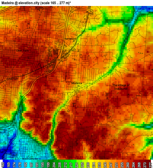
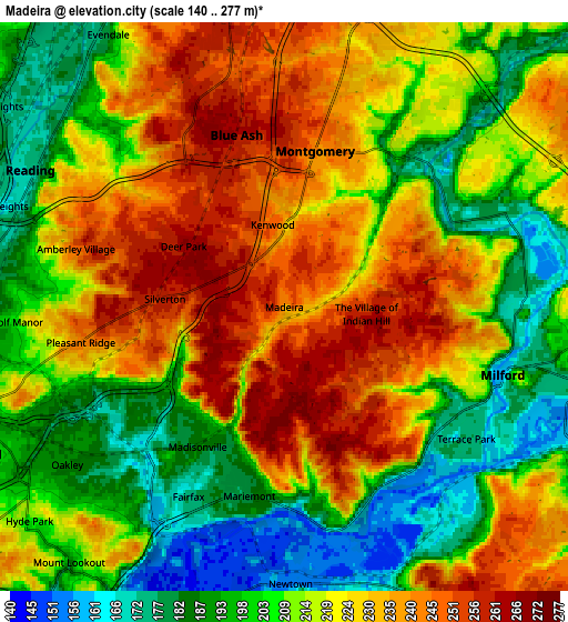
Below is the Elevation map of Madeira, which displays elevation range with different colors. Scale of the first map is from 165 to 277 m (541 to 909 ft) with average elevation of 246.1 meters (=807 ft) [note 1]
These maps also provides idea of topography and contour of this city, they are displayed at different zoom levels. More info about maps, scale and edge coordinates you can find below images.
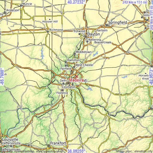
| \ | Map #1 | Map #2 | Topo.Map |
| Scale [m] | 165..277 m | 140..277 m | × |
| Scale [ft] | 541..909 ft | 459..909 ft | × |
| Average | 246.1 m = 807 ft | 216.4 m = 710 ft | × |
| Width | 7.57 km = 4.7 mi | 15.15 km = 9.4 mi | 242.4 km = 150.6 mi |
| Height | 7.57 km = 4.7 mi | 15.15 km = 9.4 mi | 242.4 km = 150.6 mi |
| ↑Max Latitude | 39.224941° | 39.258976° | 40.27232° |
| Latitude at center | 39.19089° | 39.19089° | 39.19089° |
| ↓Min Latitude | 39.156822° | 39.122738° | 38.09255° |
| ← Min Longitude | -84.407495° | -84.451441° | -85.7698° |
| Longitude center | -84.36355° | -84.36355° | -84.36355° |
| →Max Longitude | -84.319605° | -84.275659° | -82.9573° |
Nearby cities:
Cities around Madeira sort by population:
• Blue Ash elevation 260 m
4.7 km,  344°
344°
• Montgomery 243 m
4.2 km,  11°
11°
• Kenwood 247 m
2.2 km,  351°
351°
• The Village of Indian Hill 250 m
2.8 km,  117°
117°
• Deer Park 266 m
3.1 km,  300°
300°
• Silverton 260 m
3.2 km,  273°
273°
• Amberley 249 m
5.8 km,  285°
285°
• Dillonvale 245 m
4.5 km,  312°
312°
• Mariemont 181 m
5.2 km,  190°
190°
• Terrace Park 176 m
6 km,  125°
125°
• Rossmoyne 257 m
3.2 km,  321°
321°
• Fairfax 175 m
5.7 km,  206°
206°
Multilingual:
 En español:
Madeira elevación 234 m.
 En France:
Madeira élévation 234 m.


Sources and notes:
- [note 1] Map square and city borders are not equal. Map elevation data is calculated only from area inside that square.
- [src 1] Elevation data from geonames database provided with same terms of usage.
- [src 2] The elevation map of Madeira is generated using elevation data from NASA's 3 arcsec (90m) resolution SRTM data.
- [src 3] Base (background) map © OpenStreetMap contributors tiles are generated by Geofabrik and OpenTopoMap.
Copyright & License:
This Madeira Elevation Map is licensed under CC BY-SA. You may reuse any part from this page, if you give a proper credit by linking to this URL:
 More info on terms of use page.