Bethel elevation
Bethel (Ohio, Clermont County), United States elevation is 271 meters and Bethel elevation in feet is 889 ft above sea level [src 1]. Bethel is a populated place (feature code) with elevation that is 8 meters (26 ft) smaller than average city elevation in United States.
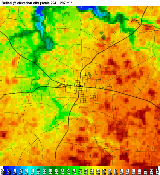
Below is the Elevation map of Bethel, which displays elevation range with different colors. Scale of the first map is from 224 to 297 m (735 to 974 ft) with average elevation of 271.4 meters (=890 ft) [note 1]
These maps also provides idea of topography and contour of this city, they are displayed at different zoom levels. More info about maps, scale and edge coordinates you can find below images.
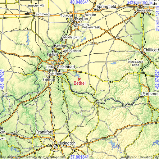
| \ | Map #1 | Topo.Map |
| Scale [m] | 224..297 m | × |
| Scale [ft] | 735..974 ft | × |
| Average | 271.4 m = 890 ft | × |
| Width | 7.6 km = 4.7 mi | 243.1 km = 151.1 mi |
| Height | 7.6 km = 4.7 mi | 243.1 km = 151.1 mi |
| ↑Max Latitude | 38.997841° | 40.04864° |
| Latitude at center | 38.96368° | 38.96368° |
| ↓Min Latitude | 38.929502° | 37.86184° |
| ← Min Longitude | -84.124715° | -85.48702° |
| Longitude center | -84.08077° | -84.08077° |
| →Max Longitude | -84.036825° | -82.67452° |
Nearby cities:
Cities around Bethel sort by population:
• Forestville elevation 253 m
26 km,  298°
298°
• Withamsville 266 m
21 km, 301°
• Summerside 268 m
23.8 km,  311°
311°
• Amelia 269 m
13.8 km, 301°
• Mount Carmel 269 m
24.9 km, 309°
• Georgetown 282 m
18.8 km,  125°
125°
• Cherry Grove 267 m
24.1 km, 300°
• Mount Orab 287 m
15.6 km,  62°
62°
• New Richmond 152 m
17.3 km,  264°
264°
• Williamsburg 249 m
10.4 km,  13°
13°
• Batavia 182 m
15.1 km,  326°
326°
• Augusta 160 m
22.3 km,  163°
163°
Multilingual:
 En español:
Bethel elevación 271 m.
 En France:
Bethel élévation 271 m.


Sources and notes:
- [note 1] Map square and city borders are not equal. Map elevation data is calculated only from area inside that square.
- [src 1] Elevation data from geonames database provided with same terms of usage.
- [src 2] The elevation map of Bethel is generated using elevation data from NASA's 3 arcsec (90m) resolution SRTM data.
- [src 3] Base (background) map © OpenStreetMap contributors tiles are generated by Geofabrik and OpenTopoMap.
Copyright & License:
This Bethel Elevation Map is licensed under CC BY-SA. You may reuse any part from this page, if you give a proper credit by linking to this URL:
 More info on terms of use page.