Wentworth elevation
Wentworth (North Carolina, Rockingham County), United States elevation is 227 meters and Wentworth elevation in feet is 745 ft above sea level [src 1]. Wentworth is a seat of a second-order administrative division (feature code) with elevation that is 52 meters (171 ft) smaller than average city elevation in United States.
Below is the Elevation map of Wentworth, which displays elevation range with different colors. Scale of the first map is from 155 to 287 m (509 to 942 ft) with average elevation of 223.5 meters (=733 ft) [note 1]
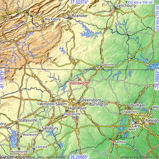
These maps also provides idea of topography and contour of this city, they are displayed at different zoom levels. More info about maps, scale and edge coordinates you can find below images.
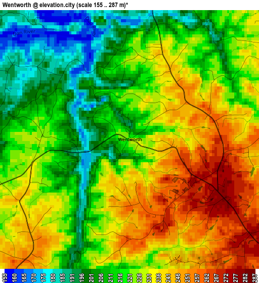
| \ | Map #1 | Topo.Map |
| Scale [m] | 155..287 m | × |
| Scale [ft] | 509..942 ft | × |
| Average | 223.5 m = 733 ft | × |
| Width | 7.87 km = 4.9 mi | 251.7 km = 156.4 mi |
| Height | 7.87 km = 4.9 mi | 251.7 km = 156.4 mi |
| ↑Max Latitude | 36.435503° | 37.52374° |
| Latitude at center | 36.40014° | 36.40014° |
| ↓Min Latitude | 36.364761° | 35.26005° |
| ← Min Longitude | -79.818425° | -81.18073° |
| Longitude center | -79.77448° | -79.77448° |
| →Max Longitude | -79.730535° | -78.36823° |
Nearby cities:
Cities around Wentworth sort by population:
• Eden elevation 178 m
9.8 km,  4°
4°
• Reidsville 244 m
11.1 km,  117°
117°
• Martinsville 309 m
33.6 km,  344°
344°
• Summerfield 276 m
24.3 km,  208°
208°
• Oak Ridge 284 m
31.7 km,  217°
217°
• Stokesdale 289 m
25.8 km,  225°
225°
• Mayodan 189 m
17.3 km,  274°
274°
• Horse Pasture 335 m
29.9 km,  328°
328°
• Madison 188 m
16.6 km,  264°
264°
• Chatmoss 203 m
28.7 km,  353°
353°
• Stoneville 249 m
14 km,  301°
301°
• McLeansville 231 m
34.2 km,  162°
162°
Multilingual:
 En español:
Wentworth elevación 227 m.
 En France:
Wentworth élévation 227 m.
 Auf Deutsch:
Wentworth höhe über dem Meeresspiegel ist 227 m.

Sources and notes:
- [note 1] Map square and city borders are not equal. Map elevation data is calculated only from area inside that square.
- [src 1] Elevation data from geonames database provided with same terms of usage.
- [src 2] The elevation map of Wentworth is generated using elevation data from NASA's 3 arcsec (90m) resolution SRTM data.
- [src 3] Base (background) map © OpenStreetMap contributors tiles are generated by Geofabrik and OpenTopoMap.
Copyright & License:
This Wentworth Elevation Map is licensed under CC BY-SA. You may reuse any part from this page, if you give a proper credit by linking to this URL:
 More info on terms of use page.