Reidsville elevation
Reidsville (North Carolina, Rockingham County), United States elevation is 244 meters and Reidsville elevation in feet is 801 ft above sea level [src 1]. Reidsville is a populated place (feature code) with elevation that is 35 meters (115 ft) smaller than average city elevation in United States.
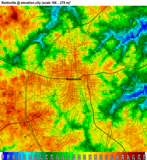
Below is the Elevation map of Reidsville, which displays elevation range with different colors. Scale of the first map is from 186 to 278 m (610 to 912 ft) with average elevation of 236.2 meters (=775 ft) [note 1]
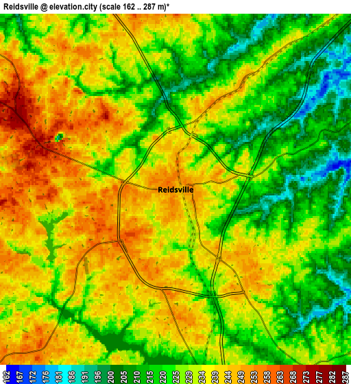
These maps also provides idea of topography and contour of this city, they are displayed at different zoom levels. More info about maps, scale and edge coordinates you can find below images.
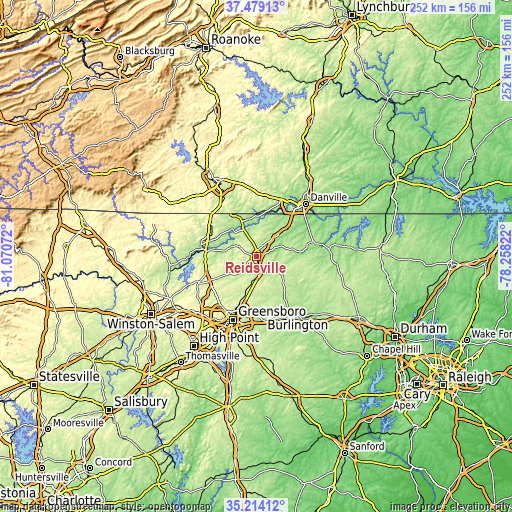
| \ | Map #1 | Map #2 | Topo.Map |
| Scale [m] | 186..278 m | 162..287 m | × |
| Scale [ft] | 610..912 ft | 531..942 ft | × |
| Average | 236.2 m = 775 ft | 229.8 m = 754 ft | × |
| Width | 7.87 km = 4.9 mi | 15.74 km = 9.8 mi | 251.8 km = 156.5 mi |
| Height | 7.87 km = 4.9 mi | 15.74 km = 9.8 mi | 251.8 km = 156.5 mi |
| ↑Max Latitude | 36.390244° | 36.425611° | 37.47913° |
| Latitude at center | 36.35486° | 36.35486° | 36.35486° |
| ↓Min Latitude | 36.31946° | 36.284044° | 35.21412° |
| ← Min Longitude | -79.708415° | -79.752361° | -81.07072° |
| Longitude center | -79.66447° | -79.66447° | -79.66447° |
| →Max Longitude | -79.620525° | -79.576579° | -78.25822° |
Nearby cities:
Cities around Reidsville sort by population:
• Eden elevation 178 m
17.4 km,  328°
328°
• Summerfield 276 m
27 km,  232°
232°
• Elon 217 m
31.4 km,  153°
153°
• Gibsonville 220 m
29.8 km,  158°
158°
• Stokesdale 289 m
31.1 km,  245°
245°
• Wentworth 227 m
11.1 km,  297°
297°
• Glen Raven 212 m
31.7 km, 147°
• Mayodan 189 m
27.8 km,  283°
283°
• Madison 188 m
26.6 km, 277°
• Yanceyville 185 m
29.9 km,  79°
79°
• Stoneville 249 m
25 km, 299°
• McLeansville 231 m
27.5 km,  178°
178°
Multilingual:
 En español:
Reidsville elevación 244 m.
 En France:
Reidsville élévation 244 m.
 Auf Deutsch:
Reidsville höhe über dem Meeresspiegel ist 244 m.

Sources and notes:
- [note 1] Map square and city borders are not equal. Map elevation data is calculated only from area inside that square.
- [src 1] Elevation data from geonames database provided with same terms of usage.
- [src 2] The elevation map of Reidsville is generated using elevation data from NASA's 3 arcsec (90m) resolution SRTM data.
- [src 3] Base (background) map © OpenStreetMap contributors tiles are generated by Geofabrik and OpenTopoMap.
Copyright & License:
This Reidsville Elevation Map is licensed under CC BY-SA. You may reuse any part from this page, if you give a proper credit by linking to this URL:
 More info on terms of use page.