Weddington elevation
Weddington (North Carolina, Union County), United States elevation is 222 meters and Weddington elevation in feet is 728 ft above sea level [src 1]. Weddington is a populated place (feature code) with elevation that is 57 meters (187 ft) smaller than average city elevation in United States.
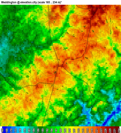
Below is the Elevation map of Weddington, which displays elevation range with different colors. Scale of the first map is from 165 to 234 m (541 to 768 ft) with average elevation of 202 meters (=663 ft) [note 1]
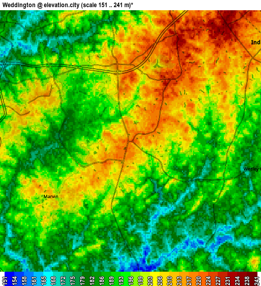
These maps also provides idea of topography and contour of this city, they are displayed at different zoom levels. More info about maps, scale and edge coordinates you can find below images.
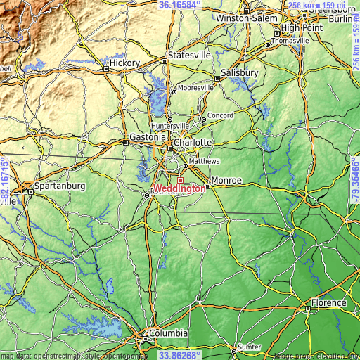
| \ | Map #1 | Map #2 | Topo.Map |
| Scale [m] | 165..234 m | 151..241 m | × |
| Scale [ft] | 541..768 ft | 495..791 ft | × |
| Average | 202 m = 663 ft | 195.3 m = 641 ft | × |
| Width | 8 km = 5 mi | 16.01 km = 9.9 mi | 256.1 km = 159.1 mi |
| Height | 8 km = 5 mi | 16.01 km = 9.9 mi | 256.1 km = 159.1 mi |
| ↑Max Latitude | 35.05835° | 35.094314° | 36.16584° |
| Latitude at center | 35.02237° | 35.02237° | 35.02237° |
| ↓Min Latitude | 34.986374° | 34.950362° | 33.86268° |
| ← Min Longitude | -80.804845° | -80.848791° | -82.16715° |
| Longitude center | -80.7609° | -80.7609° | -80.7609° |
| →Max Longitude | -80.716955° | -80.673009° | -79.35465° |
Nearby cities:
Cities around Weddington sort by population:
• Indian Trail elevation 211 m
10.3 km,  54°
54°
• Monroe 179 m
19.7 km,  102°
102°
• Matthews 226 m
11 km,  17°
17°
• Stallings 229 m
10.2 km,  41°
41°
• Fort Mill 193 m
16.9 km,  264°
264°
• Waxhaw 203 m
11 km,  171°
171°
• Pineville 176 m
13.7 km,  299°
299°
• Wesley Chapel 186 m
8 km, 102°
• Marvin 212 m
6 km,  235°
235°
• Lake Park 198 m
13.5 km,  58°
58°
• Mineral Springs 193 m
12.6 km,  138°
138°
• Hemby Bridge 193 m
15.1 km, 53°
Multilingual:
 En español:
Weddington elevación 222 m.
 En France:
Weddington élévation 222 m.
 Auf Deutsch:
Weddington höhe über dem Meeresspiegel ist 222 m.

Sources and notes:
- [note 1] Map square and city borders are not equal. Map elevation data is calculated only from area inside that square.
- [src 1] Elevation data from geonames database provided with same terms of usage.
- [src 2] The elevation map of Weddington is generated using elevation data from NASA's 3 arcsec (90m) resolution SRTM data.
- [src 3] Base (background) map © OpenStreetMap contributors tiles are generated by Geofabrik and OpenTopoMap.
Copyright & License:
This Weddington Elevation Map is licensed under CC BY-SA. You may reuse any part from this page, if you give a proper credit by linking to this URL:
 More info on terms of use page.