Marion elevation
Marion (North Carolina, McDowell County), United States elevation is 439 meters and Marion elevation in feet is 1440 ft above sea level [src 1]. Marion is a seat of a second-order administrative division (feature code) with elevation that is 160 meters (525 ft) bigger than average city elevation in United States.
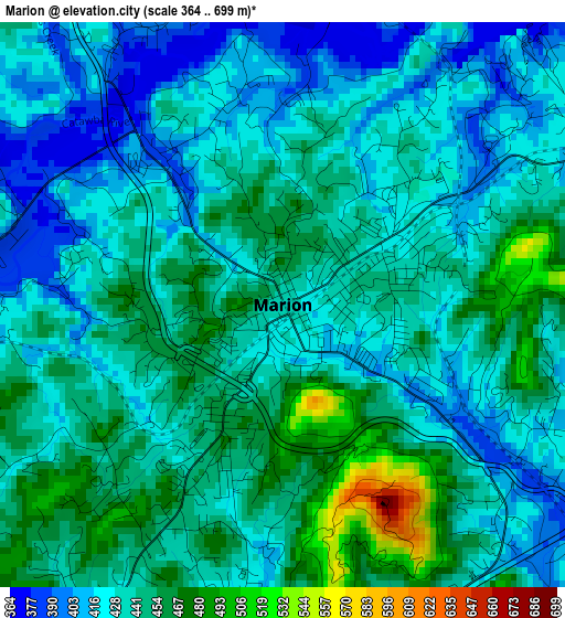
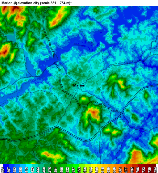
Below is the Elevation map of Marion, which displays elevation range with different colors. Scale of the first map is from 364 to 699 m (1194 to 2293 ft) with average elevation of 436.9 meters (=1433 ft) [note 1]
These maps also provides idea of topography and contour of this city, they are displayed at different zoom levels. More info about maps, scale and edge coordinates you can find below images.
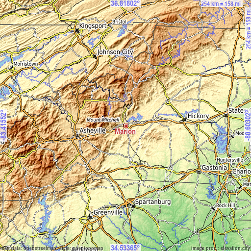
| \ | Map #1 | Map #2 | Topo.Map |
| Scale [m] | 364..699 m | 351..754 m | × |
| Scale [ft] | 1194..2293 ft | 1152..2474 ft | × |
| Average | 436.9 m = 1433 ft | 441.6 m = 1449 ft | × |
| Width | 7.94 km = 4.9 mi | 15.88 km = 9.9 mi | 254 km = 157.8 mi |
| Height | 7.94 km = 4.9 mi | 15.88 km = 9.9 mi | 254 km = 157.8 mi |
| ↑Max Latitude | 35.719696° | 35.755367° | 36.81802° |
| Latitude at center | 35.68401° | 35.68401° | 35.68401° |
| ↓Min Latitude | 35.648308° | 35.612589° | 34.53365° |
| ← Min Longitude | -82.053215° | -82.097161° | -83.41552° |
| Longitude center | -82.00927° | -82.00927° | -82.00927° |
| →Max Longitude | -81.965325° | -81.921379° | -80.60302° |
Nearby cities:
Cities around Marion sort by population:
• Morganton elevation 353 m
30.1 km,  76°
76°
• Black Mountain 733 m
29.1 km,  255°
255°
• Swannanoa 675 m
36.6 km,  254°
254°
• Spindale 338 m
36.7 km,  168°
168°
• Rutherfordton 292 m
35.3 km, 172°
• Salem 369 m
28.2 km,  86°
86°
• Spruce Pine 779 m
26.2 km,  349°
349°
• Drexel 372 m
37.5 km, 77°
• Burnsville 864 m
36.9 km,  314°
314°
• Glen Alpine 369 m
21.4 km, 76°
• West Marion 448 m
3.2 km,  206°
206°
• Lake Lure 352 m
33.5 km, 211°
Multilingual:
 En español:
Marion elevación 439 m.
 En France:
Marion élévation 439 m.


Sources and notes:
- [note 1] Map square and city borders are not equal. Map elevation data is calculated only from area inside that square.
- [src 1] Elevation data from geonames database provided with same terms of usage.
- [src 2] The elevation map of Marion is generated using elevation data from NASA's 3 arcsec (90m) resolution SRTM data.
- [src 3] Base (background) map © OpenStreetMap contributors tiles are generated by Geofabrik and OpenTopoMap.
Copyright & License:
This Marion Elevation Map is licensed under CC BY-SA. You may reuse any part from this page, if you give a proper credit by linking to this URL:
 More info on terms of use page.