Drexel elevation
Drexel (North Carolina, Burke County), United States elevation is 372 meters and Drexel elevation in feet is 1220 ft above sea level [src 1]. Drexel is a populated place (feature code) with elevation that is 93 meters (305 ft) bigger than average city elevation in United States.
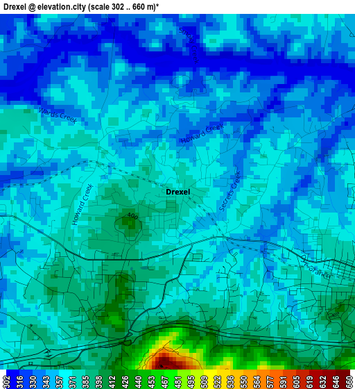
Below is the Elevation map of Drexel, which displays elevation range with different colors. Scale of the first map is from 302 to 660 m (991 to 2165 ft) with average elevation of 363.7 meters (=1193 ft) [note 1]
These maps also provides idea of topography and contour of this city, they are displayed at different zoom levels. More info about maps, scale and edge coordinates you can find below images.
| \ | Map #1 | Topo.Map |
| Scale [m] | 302..660 m | × |
| Scale [ft] | 991..2165 ft | × |
| Average | 363.7 m = 1193 ft | × |
| Width | 7.93 km = 4.9 mi | 253.8 km = 157.7 mi |
| Height | 7.93 km = 4.9 mi | 253.8 km = 157.7 mi |
| ↑Max Latitude | 35.793563° | 36.89085° |
| Latitude at center | 35.75791° | 35.75791° |
| ↓Min Latitude | 35.722241° | 34.6086° |
| ← Min Longitude | -81.648205° | -83.01051° |
| Longitude center | -81.60426° | -81.60426° |
| →Max Longitude | -81.560315° | -80.19801° |
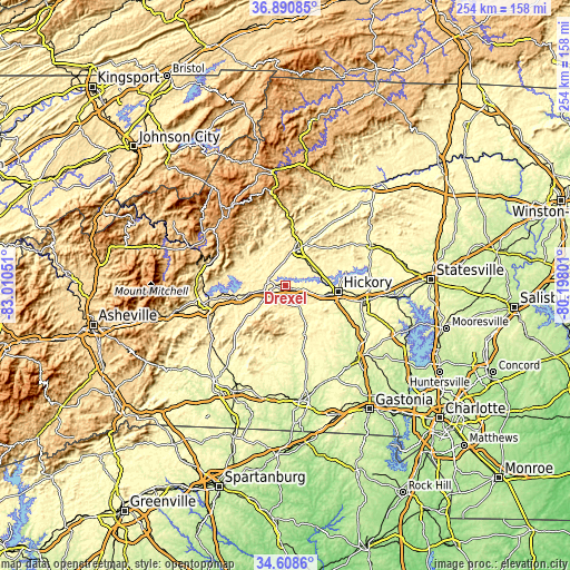
Nearby cities:
Cities around Drexel sort by population:
• Morganton elevation 353 m
7.4 km,  259°
259°
• Sawmills 375 m
13.9 km,  57°
57°
• Valdese 371 m
4.2 km,  117°
117°
• Gamewell 325 m
12.4 km,  3°
3°
• Hudson 386 m
14 km,  44°
44°
• Cajahs Mountain 403 m
10.3 km,  33°
33°
• Icard 366 m
12.5 km,  105°
105°
• Salem 369 m
10.6 km,  231°
231°
• Connelly Springs 364 m
8.4 km,  101°
101°
• Glen Alpine 369 m
16.1 km, 258°
• Rutherford College 370 m
7.4 km, 98°
• Rhodhiss 298 m
15.7 km,  83°
83°
Multilingual:
 En español:
Drexel elevación 372 m.
 En France:
Drexel élévation 372 m.


Sources and notes:
- [note 1] Map square and city borders are not equal. Map elevation data is calculated only from area inside that square.
- [src 1] Elevation data from geonames database provided with same terms of usage.
- [src 2] The elevation map of Drexel is generated using elevation data from NASA's 3 arcsec (90m) resolution SRTM data.
- [src 3] Base (background) map © OpenStreetMap contributors tiles are generated by Geofabrik and OpenTopoMap.
Copyright & License:
This Drexel Elevation Map is licensed under CC BY-SA. You may reuse any part from this page, if you give a proper credit by linking to this URL:
 More info on terms of use page.