Laurinburg elevation
Laurinburg (North Carolina, Scotland County), United States elevation is 69 meters and Laurinburg elevation in feet is 226 ft above sea level [src 1]. Laurinburg is a seat of a second-order administrative division (feature code) with elevation that is 210 meters (689 ft) smaller than average city elevation in United States.
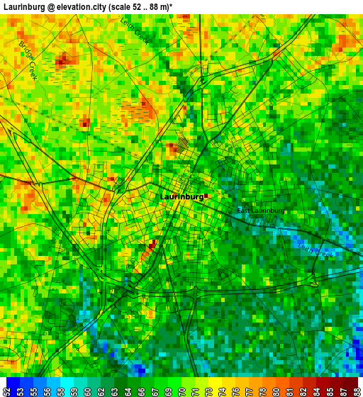
Below is the Elevation map of Laurinburg, which displays elevation range with different colors. Scale of the first map is from 52 to 88 m (171 to 289 ft) with average elevation of 68.4 meters (=224 ft) [note 1]
These maps also provides idea of topography and contour of this city, they are displayed at different zoom levels. More info about maps, scale and edge coordinates you can find below images.
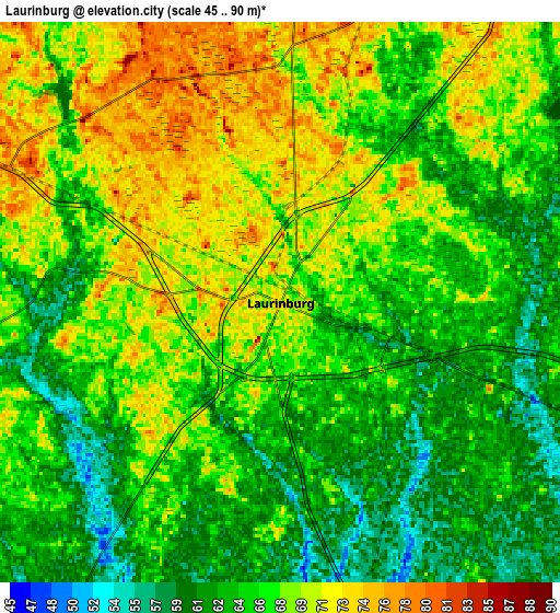
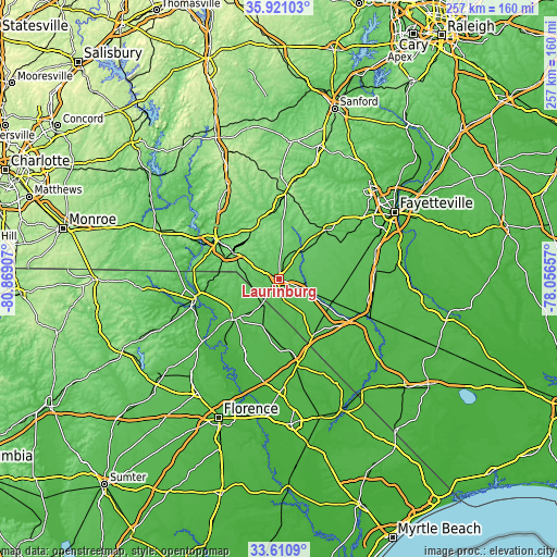
| \ | Map #1 | Map #2 | Topo.Map |
| Scale [m] | 52..88 m | 45..90 m | × |
| Scale [ft] | 171..289 ft | 148..295 ft | × |
| Average | 68.4 m = 224 ft | 66.4 m = 218 ft | × |
| Width | 8.03 km = 5 mi | 16.05 km = 10 mi | 256.9 km = 159.6 mi |
| Height | 8.03 km = 5 mi | 16.05 km = 10 mi | 256.9 km = 159.6 mi |
| ↑Max Latitude | 34.810139° | 34.846212° | 35.92103° |
| Latitude at center | 34.77405° | 34.77405° | 34.77405° |
| ↓Min Latitude | 34.737945° | 34.701824° | 33.6109° |
| ← Min Longitude | -79.506765° | -79.550711° | -80.86907° |
| Longitude center | -79.46282° | -79.46282° | -79.46282° |
| →Max Longitude | -79.418875° | -79.374929° | -78.05657° |
Nearby cities:
Cities around Laurinburg sort by population:
• Rockingham elevation 86 m
33.8 km,  302°
302°
• Bennettsville 45 m
26.7 km,  229°
229°
• Hamlet 93 m
24.5 km, 300°
• Raeford 83 m
31.7 km,  43°
43°
• East Rockingham 76 m
31.7 km, 300°
• Red Springs 62 m
25.9 km,  79°
79°
• Pembroke 47 m
26.6 km,  113°
113°
• Maxton 61 m
11.3 km, 112°
• McColl 59 m
13.9 km,  212°
212°
• Cordova 88 m
36.2 km, 295°
• Laurel Hill 76 m
8.7 km, 296°
• Rowland 40 m
30.7 km,  149°
149°
Multilingual:
 En español:
Laurinburg elevación 69 m.
 En France:
Laurinburg élévation 69 m.
 Auf Deutsch:
Laurinburg höhe über dem Meeresspiegel ist 69 m.

Sources and notes:
- [note 1] Map square and city borders are not equal. Map elevation data is calculated only from area inside that square.
- [src 1] Elevation data from geonames database provided with same terms of usage.
- [src 2] The elevation map of Laurinburg is generated using elevation data from NASA's 3 arcsec (90m) resolution SRTM data.
- [src 3] Base (background) map © OpenStreetMap contributors tiles are generated by Geofabrik and OpenTopoMap.
Copyright & License:
This Laurinburg Elevation Map is licensed under CC BY-SA. You may reuse any part from this page, if you give a proper credit by linking to this URL:
 More info on terms of use page.