Boone elevation
Boone (North Carolina, Watauga County), United States elevation is 984 meters and Boone elevation in feet is 3228 ft above sea level [src 1]. Boone is a seat of a second-order administrative division (feature code) with elevation that is 705 meters (2313 ft) bigger than average city elevation in United States.
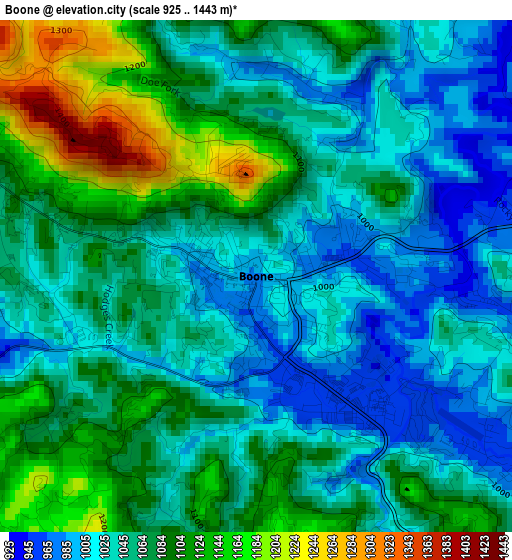
Below is the Elevation map of Boone, which displays elevation range with different colors. Scale of the first map is from 925 to 1443 m (3035 to 4734 ft) with average elevation of 1062.4 meters (=3486 ft) [note 1]
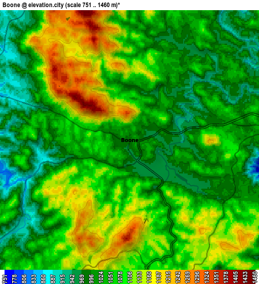
These maps also provides idea of topography and contour of this city, they are displayed at different zoom levels. More info about maps, scale and edge coordinates you can find below images.
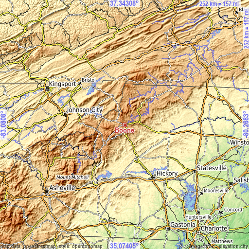
| \ | Map #1 | Map #2 | Topo.Map |
| Scale [m] | 925..1443 m | 751..1460 m | × |
| Scale [ft] | 3035..4734 ft | 2464..4790 ft | × |
| Average | 1062.4 m = 3486 ft | 1061.5 m = 3483 ft | × |
| Width | 7.88 km = 4.9 mi | 15.77 km = 9.8 mi | 252.3 km = 156.8 mi |
| Height | 7.88 km = 4.9 mi | 15.77 km = 9.8 mi | 252.3 km = 156.8 mi |
| ↑Max Latitude | 36.252236° | 36.287667° | 37.34308° |
| Latitude at center | 36.21679° | 36.21679° | 36.21679° |
| ↓Min Latitude | 36.181327° | 36.145849° | 35.07405° |
| ← Min Longitude | -81.718495° | -81.762441° | -83.0808° |
| Longitude center | -81.67455° | -81.67455° | -81.67455° |
| →Max Longitude | -81.630605° | -81.586659° | -80.2683° |
Nearby cities:
Cities around Boone sort by population:
• Lenoir elevation 359 m
35.8 km,  160°
160°
• Gamewell 325 m
39.3 km,  169°
169°
• Mountain City 739 m
30.9 km,  337°
337°
• Millers Creek 430 m
39.3 km,  94°
94°
• Cricket 384 m
43.4 km,  96°
96°
• Jefferson 888 m
28.9 km,  38°
38°
• Foscoe 924 m
10.2 km,  233°
233°
• Roan Mountain 786 m
35.6 km,  266°
266°
• West Jefferson 906 m
26.4 km, 38°
• Blowing Rock 1088 m
9.1 km,  181°
181°
• Banner Elk 1130 m
18.7 km,  251°
251°
• Newland 1101 m
26.9 km,  237°
237°
Multilingual:
 En español:
Boone elevación 984 m.
 En France:
Boone élévation 984 m.


Sources and notes:
- [note 1] Map square and city borders are not equal. Map elevation data is calculated only from area inside that square.
- [src 1] Elevation data from geonames database provided with same terms of usage.
- [src 2] The elevation map of Boone is generated using elevation data from NASA's 3 arcsec (90m) resolution SRTM data.
- [src 3] Base (background) map © OpenStreetMap contributors tiles are generated by Geofabrik and OpenTopoMap.
Copyright & License:
This Boone Elevation Map is licensed under CC BY-SA. You may reuse any part from this page, if you give a proper credit by linking to this URL:
 More info on terms of use page.