Ridgeland elevation
Ridgeland (Mississippi, Madison County), United States elevation is 113 meters and Ridgeland elevation in feet is 371 ft above sea level [src 1]. Ridgeland is a populated place (feature code) with elevation that is 166 meters (545 ft) smaller than average city elevation in United States.
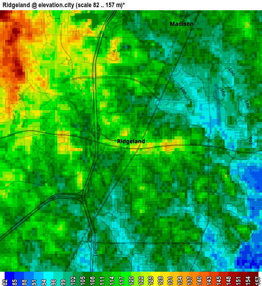
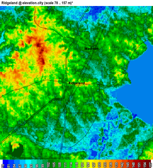
Below is the Elevation map of Ridgeland, which displays elevation range with different colors. Scale of the first map is from 82 to 157 m (269 to 515 ft) with average elevation of 110.1 meters (=361 ft) [note 1]
These maps also provides idea of topography and contour of this city, they are displayed at different zoom levels. More info about maps, scale and edge coordinates you can find below images.
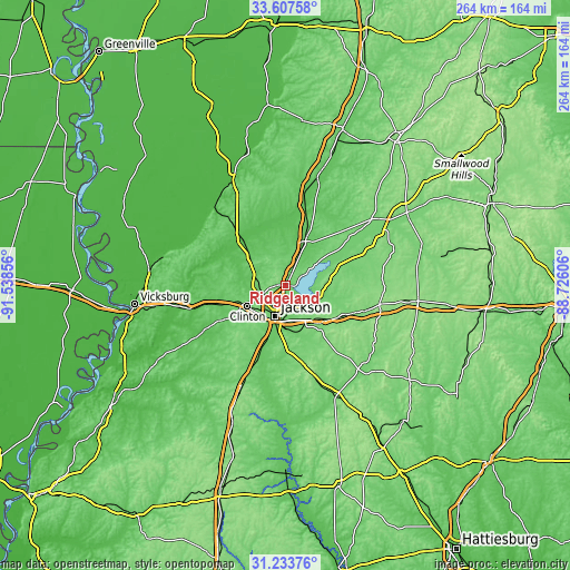
| \ | Map #1 | Map #2 | Topo.Map |
| Scale [m] | 82..157 m | 78..157 m | × |
| Scale [ft] | 269..515 ft | 256..515 ft | × |
| Average | 110.1 m = 361 ft | 106 m = 348 ft | × |
| Width | 8.25 km = 5.1 mi | 16.5 km = 10.3 mi | 263.9 km = 164 mi |
| Height | 8.25 km = 5.1 mi | 16.5 km = 10.3 mi | 263.9 km = 164 mi |
| ↑Max Latitude | 32.465565° | 32.502635° | 33.60758° |
| Latitude at center | 32.42848° | 32.42848° | 32.42848° |
| ↓Min Latitude | 32.39138° | 32.354264° | 31.23376° |
| ← Min Longitude | -90.176255° | -90.220201° | -91.53856° |
| Longitude center | -90.13231° | -90.13231° | -90.13231° |
| →Max Longitude | -90.088365° | -90.044419° | -88.72606° |
Nearby cities:
Cities around Ridgeland sort by population:
• Jackson elevation 100 m
15.2 km,  198°
198°
• Pearl 89 m
17.1 km,  179°
179°
• Madison 108 m
4 km,  23°
23°
• Clinton 116 m
20.2 km,  241°
241°
• Brandon 147 m
22.1 km,  141°
141°
• Canton 76 m
22.4 km, 23°
• Byram 81 m
29.7 km, 200°
• Flowood 88 m
13.2 km, 182°
• Richland 85 m
21.2 km,  186°
186°
• Flora 75 m
20.9 km,  307°
307°
• Cleary 122 m
29.6 km, 188°
• Kearney Park 66 m
24.8 km,  316°
316°
Multilingual:
 En español:
Ridgeland elevación 113 m.
 En France:
Ridgeland élévation 113 m.
 Auf Deutsch:
Ridgeland höhe über dem Meeresspiegel ist 113 m.

Sources and notes:
- [note 1] Map square and city borders are not equal. Map elevation data is calculated only from area inside that square.
- [src 1] Elevation data from geonames database provided with same terms of usage.
- [src 2] The elevation map of Ridgeland is generated using elevation data from NASA's 3 arcsec (90m) resolution SRTM data.
- [src 3] Base (background) map © OpenStreetMap contributors tiles are generated by Geofabrik and OpenTopoMap.
Copyright & License:
This Ridgeland Elevation Map is licensed under CC BY-SA. You may reuse any part from this page, if you give a proper credit by linking to this URL:
 More info on terms of use page.