Louisville elevation
Louisville (Mississippi, Winston County), United States elevation is 176 meters and Louisville elevation in feet is 577 ft above sea level [src 1]. Louisville is a seat of a second-order administrative division (feature code) with elevation that is 103 meters (338 ft) smaller than average city elevation in United States.
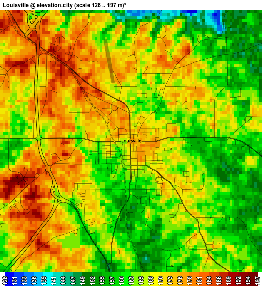
Below is the Elevation map of Louisville, which displays elevation range with different colors. Scale of the first map is from 128 to 197 m (420 to 646 ft) with average elevation of 167.1 meters (=548 ft) [note 1]
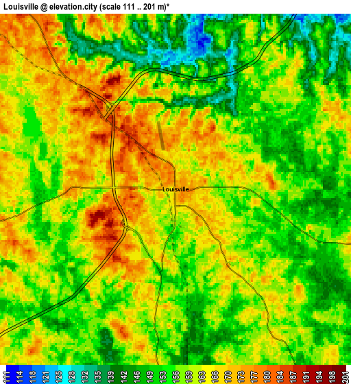
These maps also provides idea of topography and contour of this city, they are displayed at different zoom levels. More info about maps, scale and edge coordinates you can find below images.
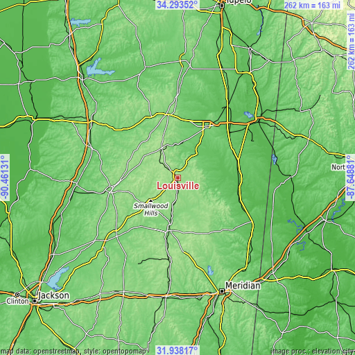
| \ | Map #1 | Map #2 | Topo.Map |
| Scale [m] | 128..197 m | 111..201 m | × |
| Scale [ft] | 420..646 ft | 364..659 ft | × |
| Average | 167.1 m = 548 ft | 158.8 m = 521 ft | × |
| Width | 8.18 km = 5.1 mi | 16.37 km = 10.2 mi | 261.9 km = 162.7 mi |
| Height | 8.18 km = 5.1 mi | 16.37 km = 10.2 mi | 261.9 km = 162.7 mi |
| ↑Max Latitude | 33.160536° | 33.197317° | 34.29352° |
| Latitude at center | 33.12374° | 33.12374° | 33.12374° |
| ↓Min Latitude | 33.086928° | 33.050101° | 31.93817° |
| ← Min Longitude | -89.099005° | -89.142951° | -90.46131° |
| Longitude center | -89.05506° | -89.05506° | -89.05506° |
| →Max Longitude | -89.011115° | -88.967169° | -87.64881° |
Nearby cities:
Cities around Louisville sort by population:
• Starkville elevation 104 m
42.4 km,  31°
31°
• Philadelphia 128 m
39.6 km,  188°
188°
• Kosciusko 149 m
50.3 km,  261°
261°
• Pearl River 162 m
41.1 km,  203°
203°
• Macon 60 m
46.1 km,  92°
92°
• Eupora 119 m
50.4 km,  336°
336°
• Union 151 m
61.7 km, 185°
• Coldwater 145 m
47.8 km, 198°
• Ackerman 158 m
23.4 km,  332°
332°
• Brooksville 86 m
45.7 km,  74°
74°
• De Kalb 141 m
54.7 km,  136°
136°
• Walthall 145 m
57.6 km, 339°
Multilingual:
 En español:
Louisville elevación 176 m.
 En France:
Louisville élévation 176 m.
 Auf Deutsch:
Louisville höhe über dem Meeresspiegel ist 176 m.

Sources and notes:
- [note 1] Map square and city borders are not equal. Map elevation data is calculated only from area inside that square.
- [src 1] Elevation data from geonames database provided with same terms of usage.
- [src 2] The elevation map of Louisville is generated using elevation data from NASA's 3 arcsec (90m) resolution SRTM data.
- [src 3] Base (background) map © OpenStreetMap contributors tiles are generated by Geofabrik and OpenTopoMap.
Copyright & License:
This Louisville Elevation Map is licensed under CC BY-SA. You may reuse any part from this page, if you give a proper credit by linking to this URL:
 More info on terms of use page.