Hillsboro elevation
Hillsboro (Mississippi, Scott County), United States elevation is 136 meters and Hillsboro elevation in feet is 446 ft above sea level [src 1]. Hillsboro is a populated place (feature code) with elevation that is 143 meters (469 ft) smaller than average city elevation in United States.
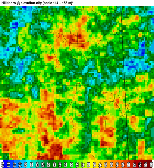
Below is the Elevation map of Hillsboro, which displays elevation range with different colors. Scale of the first map is from 114 to 156 m (374 to 512 ft) with average elevation of 133.3 meters (=437 ft) [note 1]
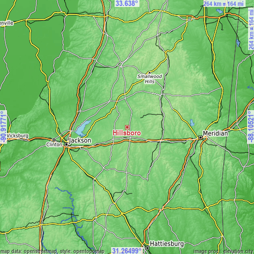
These maps also provides idea of topography and contour of this city, they are displayed at different zoom levels. More info about maps, scale and edge coordinates you can find below images.
| \ | Map #1 | Topo.Map |
| Scale [m] | 114..156 m | × |
| Scale [ft] | 374..512 ft | × |
| Average | 133.3 m = 437 ft | × |
| Width | 8.25 km = 5.1 mi | 263.9 km = 164 mi |
| Height | 8.25 km = 5.1 mi | 263.9 km = 164 mi |
| ↑Max Latitude | 32.496382° | 33.638° |
| Latitude at center | 32.45931° | 32.45931° |
| ↓Min Latitude | 32.422223° | 31.26499° |
| ← Min Longitude | -89.555405° | -90.91771° |
| Longitude center | -89.51146° | -89.51146° |
| →Max Longitude | -89.467515° | -88.10521° |
Nearby cities:
Cities around Hillsboro sort by population:
• Forest elevation 149 m
11.1 km,  161°
161°
• Carthage 108 m
30.5 km,  355°
355°
• Pearl River 162 m
44.8 km,  36°
36°
• Morton 152 m
17.8 km,  228°
228°
• Newton 130 m
36.1 km,  115°
115°
• Union 151 m
38.6 km,  71°
71°
• Decatur 135 m
37.9 km,  93°
93°
• Walnut Grove 110 m
15.4 km,  18°
18°
• Coldwater 145 m
39.8 km, 44°
• Raleigh 165 m
47.4 km,  181°
181°
• Pelahatchie 114 m
31.5 km,  238°
238°
• Conehatta 154 m
21.2 km, 92°
Multilingual:
 En español:
Hillsboro elevación 136 m.
 En France:
Hillsboro élévation 136 m.
 Auf Deutsch:
Hillsboro höhe über dem Meeresspiegel ist 136 m.

Sources and notes:
- [note 1] Map square and city borders are not equal. Map elevation data is calculated only from area inside that square.
- [src 1] Elevation data from geonames database provided with same terms of usage.
- [src 2] The elevation map of Hillsboro is generated using elevation data from NASA's 3 arcsec (90m) resolution SRTM data.
- [src 3] Base (background) map © OpenStreetMap contributors tiles are generated by Geofabrik and OpenTopoMap.
Copyright & License:
This Hillsboro Elevation Map is licensed under CC BY-SA. You may reuse any part from this page, if you give a proper credit by linking to this URL:
 More info on terms of use page.