Columbia elevation
Columbia (Mississippi, Marion County), United States elevation is 48 meters and Columbia elevation in feet is 157 ft above sea level [src 1]. Columbia is a seat of a second-order administrative division (feature code) with elevation that is 231 meters (758 ft) smaller than average city elevation in United States.
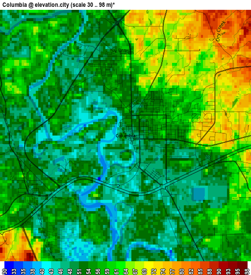
Below is the Elevation map of Columbia, which displays elevation range with different colors. Scale of the first map is from 30 to 98 m (98 to 322 ft) with average elevation of 56.1 meters (=184 ft) [note 1]
These maps also provides idea of topography and contour of this city, they are displayed at different zoom levels. More info about maps, scale and edge coordinates you can find below images.
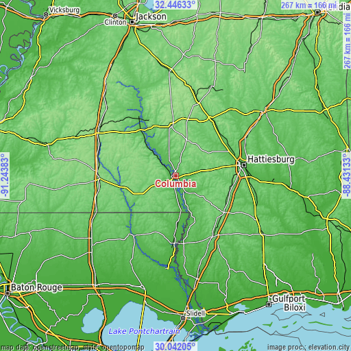
| \ | Map #1 | Map #2 | Topo.Map |
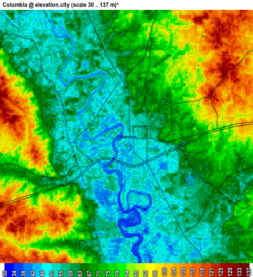
| Scale [m] | 30..98 m | 30..137 m | × |
| Scale [ft] | 98..322 ft | 98..449 ft | × |
| Average | 56.1 m = 184 ft | 71.8 m = 236 ft | × |
| Width | 8.35 km = 5.2 mi | 16.71 km = 10.4 mi | 267.3 km = 166.1 mi |
| Height | 8.35 km = 5.2 mi | 16.71 km = 10.4 mi | 267.3 km = 166.1 mi |
| ↑Max Latitude | 31.289401° | 31.326947° | 32.44633° |
| Latitude at center | 31.25184° | 31.25184° | 31.25184° |
| ↓Min Latitude | 31.214264° | 31.176673° | 30.04205° |
| ← Min Longitude | -89.881525° | -89.925471° | -91.24383° |
| Longitude center | -89.83758° | -89.83758° | -89.83758° |
| →Max Longitude | -89.793635° | -89.749689° | -88.43133° |
Nearby cities:
Cities around Columbia sort by population:
• Bogalusa elevation 39 m
51.2 km,  181°
181°
• Holly Springs 99 m
15.1 km,  298°
298°
• West Hattiesburg 85 m
44.6 km,  80°
80°
• Collins 89 m
51.3 km,  31°
31°
• Purvis 118 m
42.4 km,  106°
106°
• Lumberton 92 m
46.1 km,  127°
127°
• Arnold Line 73 m
45.1 km, 78°
• Sumrall 94 m
33.5 km,  56°
56°
• Monticello 60 m
42.2 km,  322°
322°
• Tylertown 91 m
32.7 km,  242°
242°
• Rawls Springs 58 m
46.5 km,  72°
72°
• Prentiss 105 m
38.6 km,  355°
355°
Multilingual:
 En español:
Columbia elevación 48 m.
 En France:
Columbia élévation 48 m.


Sources and notes:
- [note 1] Map square and city borders are not equal. Map elevation data is calculated only from area inside that square.
- [src 1] Elevation data from geonames database provided with same terms of usage.
- [src 2] The elevation map of Columbia is generated using elevation data from NASA's 3 arcsec (90m) resolution SRTM data.
- [src 3] Base (background) map © OpenStreetMap contributors tiles are generated by Geofabrik and OpenTopoMap.
Copyright & License:
This Columbia Elevation Map is licensed under CC BY-SA. You may reuse any part from this page, if you give a proper credit by linking to this URL:
 More info on terms of use page.