Holden elevation
Holden (Missouri, Johnson County), United States elevation is 263 meters and Holden elevation in feet is 863 ft above sea level [src 1]. Holden is a populated place (feature code) with elevation that is 16 meters (52 ft) smaller than average city elevation in United States.
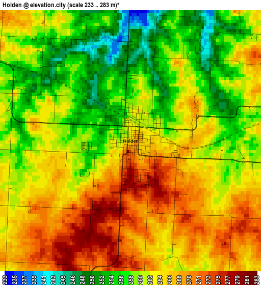
Below is the Elevation map of Holden, which displays elevation range with different colors. Scale of the first map is from 233 to 283 m (764 to 928 ft) with average elevation of 261.9 meters (=859 ft) [note 1]
These maps also provides idea of topography and contour of this city, they are displayed at different zoom levels. More info about maps, scale and edge coordinates you can find below images.
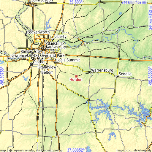
| \ | Map #1 | Topo.Map |
| Scale [m] | 233..283 m | × |
| Scale [ft] | 764..928 ft | × |
| Average | 261.9 m = 859 ft | × |
| Width | 7.63 km = 4.7 mi | 244 km = 151.6 mi |
| Height | 7.63 km = 4.7 mi | 244 km = 151.6 mi |
| ↑Max Latitude | 38.748461° | 39.803° |
| Latitude at center | 38.71418° | 38.71418° |
| ↓Min Latitude | 38.679882° | 37.60852° |
| ← Min Longitude | -94.035275° | -95.39758° |
| Longitude center | -93.99133° | -93.99133° |
| →Max Longitude | -93.947385° | -92.58508° |
Nearby cities:
Cities around Holden sort by population:
• Warrensburg elevation 270 m
22.8 km,  76°
76°
• Harrisonville 295 m
31.8 km,  257°
257°
• Pleasant Hill 282 m
25.5 km,  288°
288°
• Oak Grove 271 m
34.5 km,  339°
339°
• Greenwood 295 m
34.2 km,  296°
296°
• Odessa 288 m
31.9 km,  5°
5°
• Knob Noster 245 m
38 km, 81°
• Whiteman Air Force Base 260 m
37.6 km,  87°
87°
• Lake Lotawana 281 m
31.9 km,  316°
316°
• Garden City 285 m
24.3 km,  225°
225°
• Lake Winnebago 298 m
34.4 km, 292°
• Lone Jack 316 m
23.5 km, 317°
Multilingual:
 En español:
Holden elevación 263 m.
 En France:
Holden élévation 263 m.


Sources and notes:
- [note 1] Map square and city borders are not equal. Map elevation data is calculated only from area inside that square.
- [src 1] Elevation data from geonames database provided with same terms of usage.
- [src 2] The elevation map of Holden is generated using elevation data from NASA's 3 arcsec (90m) resolution SRTM data.
- [src 3] Base (background) map © OpenStreetMap contributors tiles are generated by Geofabrik and OpenTopoMap.
Copyright & License:
This Holden Elevation Map is licensed under CC BY-SA. You may reuse any part from this page, if you give a proper credit by linking to this URL:
 More info on terms of use page.