Hannibal elevation
Hannibal (Missouri, Marion County), United States elevation is 158 meters and Hannibal elevation in feet is 518 ft above sea level [src 1]. Hannibal is a populated place (feature code) with elevation that is 121 meters (397 ft) smaller than average city elevation in United States.
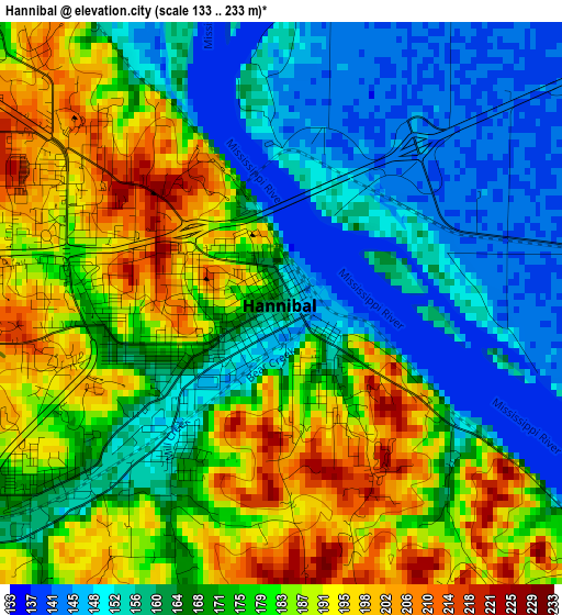
Below is the Elevation map of Hannibal, which displays elevation range with different colors. Scale of the first map is from 133 to 233 m (436 to 764 ft) with average elevation of 172.4 meters (=566 ft) [note 1]
These maps also provides idea of topography and contour of this city, they are displayed at different zoom levels. More info about maps, scale and edge coordinates you can find below images.
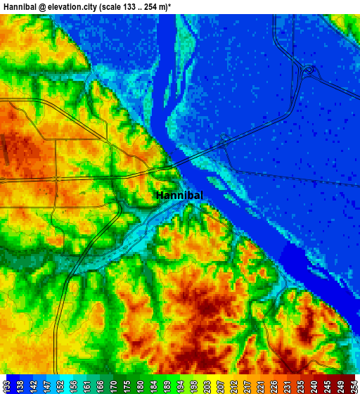

| \ | Map #1 | Map #2 | Topo.Map |
| Scale [m] | 133..233 m | 133..254 m | × |
| Scale [ft] | 436..764 ft | 436..833 ft | × |
| Average | 172.4 m = 566 ft | 176.3 m = 578 ft | × |
| Width | 7.52 km = 4.7 mi | 15.04 km = 9.3 mi | 240.6 km = 149.5 mi |
| Height | 7.52 km = 4.7 mi | 15.04 km = 9.3 mi | 240.6 km = 149.5 mi |
| ↑Max Latitude | 39.742179° | 39.775962° | 40.78172° |
| Latitude at center | 39.70838° | 39.70838° | 39.70838° |
| ↓Min Latitude | 39.674564° | 39.640732° | 38.61808° |
| ← Min Longitude | -91.402425° | -91.446371° | -92.76473° |
| Longitude center | -91.35848° | -91.35848° | -91.35848° |
| →Max Longitude | -91.314535° | -91.270589° | -89.95223° |
Nearby cities:
Cities around Hannibal sort by population:
• Quincy elevation 167 m
25.6 km,  350°
350°
• Bowling Green 274 m
43.1 km,  161°
161°
• Pittsfield 226 m
48.7 km,  103°
103°
• Vandalia 231 m
45.6 km,  194°
194°
• Palmyra 201 m
17 km,  304°
304°
• Louisiana 147 m
39 km,  137°
137°
• Monroe City 228 m
32.8 km,  259°
259°
• Canton 183 m
51.6 km,  333°
333°
• Barry 222 m
27.4 km,  93°
93°
• Camp Point 222 m
44.3 km,  33°
33°
• Payson 230 m
15.6 km,  39°
39°
• New London 203 m
14.2 km, 194°
Multilingual:
 En español:
Hannibal elevación 158 m.
 En France:
Hannibal élévation 158 m.
 Auf Deutsch:
Hannibal höhe über dem Meeresspiegel ist 158 m.

Sources and notes:
- [note 1] Map square and city borders are not equal. Map elevation data is calculated only from area inside that square.
- [src 1] Elevation data from geonames database provided with same terms of usage.
- [src 2] The elevation map of Hannibal is generated using elevation data from NASA's 3 arcsec (90m) resolution SRTM data.
- [src 3] Base (background) map © OpenStreetMap contributors tiles are generated by Geofabrik and OpenTopoMap.
Copyright & License:
This Hannibal Elevation Map is licensed under CC BY-SA. You may reuse any part from this page, if you give a proper credit by linking to this URL:
 More info on terms of use page.