Gainesville elevation
Gainesville (Missouri, Ozark County), United States elevation is 241 meters and Gainesville elevation in feet is 791 ft above sea level [src 1]. Gainesville is a seat of a second-order administrative division (feature code) with elevation that is 38 meters (125 ft) smaller than average city elevation in United States.
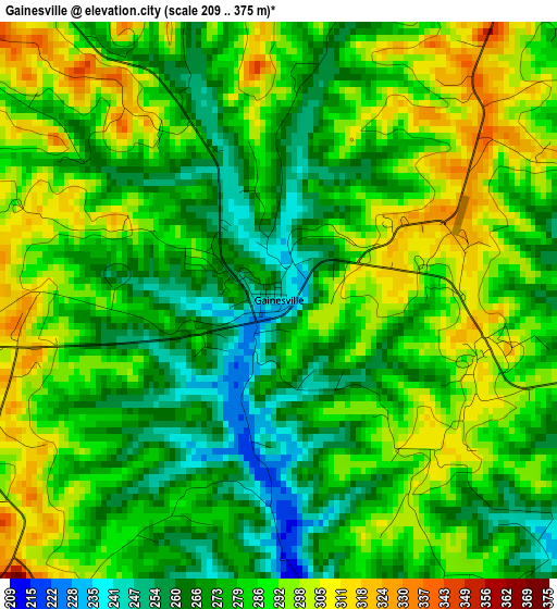
Below is the Elevation map of Gainesville, which displays elevation range with different colors. Scale of the first map is from 209 to 375 m (686 to 1230 ft) with average elevation of 282.1 meters (=926 ft) [note 1]
These maps also provides idea of topography and contour of this city, they are displayed at different zoom levels. More info about maps, scale and edge coordinates you can find below images.
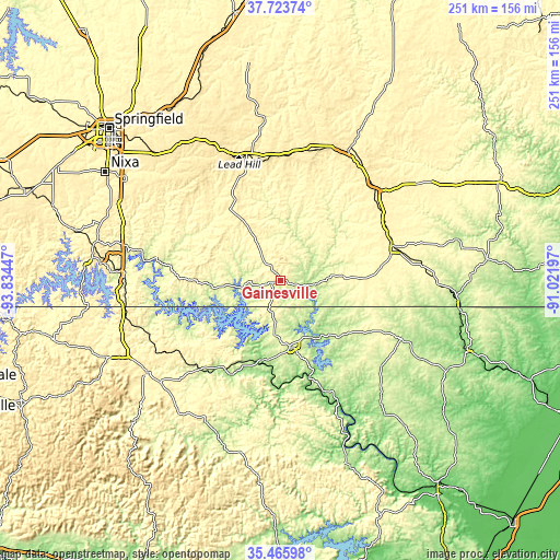
| \ | Map #1 | Topo.Map |
| Scale [m] | 209..375 m | × |
| Scale [ft] | 686..1230 ft | × |
| Average | 282.1 m = 926 ft | × |
| Width | 7.85 km = 4.9 mi | 251 km = 156 mi |
| Height | 7.85 km = 4.9 mi | 251 km = 156 mi |
| ↑Max Latitude | 36.638391° | 37.72374° |
| Latitude at center | 36.60312° | 36.60312° |
| ↓Min Latitude | 36.567833° | 35.46598° |
| ← Min Longitude | -92.472165° | -93.83447° |
| Longitude center | -92.42822° | -92.42822° |
| →Max Longitude | -92.384275° | -91.02197° |
Nearby cities:
Cities around Gainesville sort by population:
• Mountain Home elevation 250 m
30 km,  172°
172°
• West Plains 307 m
53.2 km,  74°
74°
• Ava 393 m
44 km,  331°
331°
• Willow Springs 388 m
59.5 km,  43°
43°
• Gassville 237 m
36.1 km,  189°
189°
• Bull Shoals 245 m
28 km,  209°
209°
• Calico Rock 130 m
59.8 km,  154°
154°
• Flippin 202 m
39.1 km,  202°
202°
• Mansfield 452 m
57.6 km,  346°
346°
• Yellville 194 m
47.8 km, 208°
• Kissee Mills 304 m
56.2 km,  279°
279°
• Midway 278 m
24.4 km, 187°
Multilingual:
 En español:
Gainesville elevación 241 m.
 En France:
Gainesville élévation 241 m.
 Auf Deutsch:
Gainesville höhe über dem Meeresspiegel ist 241 m.

Sources and notes:
- [note 1] Map square and city borders are not equal. Map elevation data is calculated only from area inside that square.
- [src 1] Elevation data from geonames database provided with same terms of usage.
- [src 2] The elevation map of Gainesville is generated using elevation data from NASA's 3 arcsec (90m) resolution SRTM data.
- [src 3] Base (background) map © OpenStreetMap contributors tiles are generated by Geofabrik and OpenTopoMap.
Copyright & License:
This Gainesville Elevation Map is licensed under CC BY-SA. You may reuse any part from this page, if you give a proper credit by linking to this URL:
 More info on terms of use page.