Bull Shoals elevation
Bull Shoals (Arkansas, Marion County), United States elevation is 245 meters and Bull Shoals elevation in feet is 804 ft above sea level [src 1]. Bull Shoals is a populated place (feature code) with elevation that is 34 meters (112 ft) smaller than average city elevation in United States.
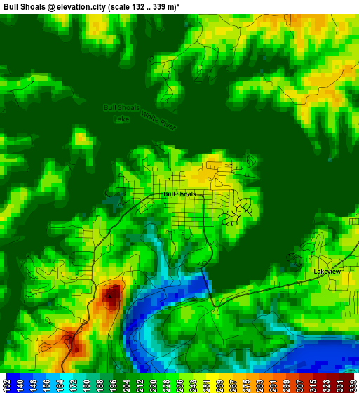
Below is the Elevation map of Bull Shoals, which displays elevation range with different colors. Scale of the first map is from 132 to 339 m (433 to 1112 ft) with average elevation of 214 meters (=702 ft) [note 1]
These maps also provides idea of topography and contour of this city, they are displayed at different zoom levels. More info about maps, scale and edge coordinates you can find below images.
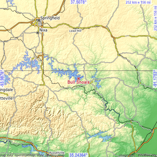
| \ | Map #1 | Topo.Map |
| Scale [m] | 132..339 m | × |
| Scale [ft] | 433..1112 ft | × |
| Average | 214 m = 702 ft | × |
| Width | 7.87 km = 4.9 mi | 251.8 km = 156.5 mi |
| Height | 7.87 km = 4.9 mi | 251.7 km = 156.4 mi |
| ↑Max Latitude | 36.419331° | 37.5078° |
| Latitude at center | 36.38396° | 36.38396° |
| ↓Min Latitude | 36.348573° | 35.24364° |
| ← Min Longitude | -92.625495° | -93.9878° |
| Longitude center | -92.58155° | -92.58155° |
| →Max Longitude | -92.537605° | -91.1753° |
Nearby cities:
Cities around Bull Shoals sort by population:
• Harrison elevation 320 m
50.2 km,  250°
250°
• Mountain Home 250 m
18.4 km,  107°
107°
• Hollister 226 m
62.5 km,  294°
294°
• Forsyth 285 m
58.6 km,  304°
304°
• Gassville 237 m
13.7 km,  145°
145°
• Calico Rock 130 m
49.6 km,  126°
126°
• Flippin 202 m
11.8 km,  186°
186°
• Marshall 321 m
53 km,  184°
184°
• Yellville 194 m
19.8 km,  207°
207°
• Kissee Mills 304 m
53.5 km,  308°
308°
• Midway 278 m
10.7 km,  89°
89°
• Gainesville 241 m
28 km,  29°
29°
Multilingual:
 En español:
Bull Shoals elevación 245 m.
 En France:
Bull Shoals élévation 245 m.
 Auf Deutsch:
Bull Shoals höhe über dem Meeresspiegel ist 245 m.

Sources and notes:
- [note 1] Map square and city borders are not equal. Map elevation data is calculated only from area inside that square.
- [src 1] Elevation data from geonames database provided with same terms of usage.
- [src 2] The elevation map of Bull Shoals is generated using elevation data from NASA's 3 arcsec (90m) resolution SRTM data.
- [src 3] Base (background) map © OpenStreetMap contributors tiles are generated by Geofabrik and OpenTopoMap.
Copyright & License:
This Bull Shoals Elevation Map is licensed under CC BY-SA. You may reuse any part from this page, if you give a proper credit by linking to this URL:
 More info on terms of use page.