Crocker elevation
Crocker (Missouri, Pulaski County), United States elevation is 344 meters and Crocker elevation in feet is 1129 ft above sea level [src 1]. Crocker is a populated place (feature code) with elevation that is 65 meters (213 ft) bigger than average city elevation in United States.
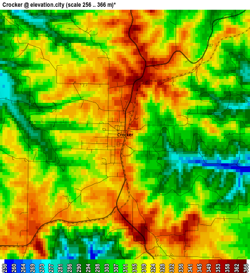
Below is the Elevation map of Crocker, which displays elevation range with different colors. Scale of the first map is from 256 to 366 m (840 to 1201 ft) with average elevation of 316.2 meters (=1037 ft) [note 1]
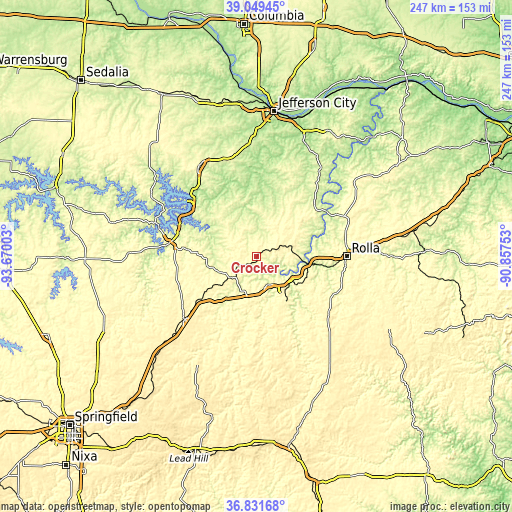
These maps also provides idea of topography and contour of this city, they are displayed at different zoom levels. More info about maps, scale and edge coordinates you can find below images.
| \ | Map #1 | Topo.Map |
| Scale [m] | 256..366 m | × |
| Scale [ft] | 840..1201 ft | × |
| Average | 316.2 m = 1037 ft | × |
| Width | 7.71 km = 4.8 mi | 246.6 km = 153.2 mi |
| Height | 7.71 km = 4.8 mi | 246.6 km = 153.2 mi |
| ↑Max Latitude | 37.983575° | 39.04945° |
| Latitude at center | 37.94893° | 37.94893° |
| ↓Min Latitude | 37.914268° | 36.83168° |
| ← Min Longitude | -92.307725° | -93.67003° |
| Longitude center | -92.26378° | -92.26378° |
| →Max Longitude | -92.219835° | -90.85753° |
Nearby cities:
Cities around Crocker sort by population:
• Rolla elevation 342 m
43.2 km,  89°
89°
• Fort Leonard Wood 339 m
28.6 km,  160°
160°
• Lebanon 386 m
46.1 km,  229°
229°
• Waynesville 253 m
14.5 km, 157°
• Osage Beach 236 m
39.5 km,  300°
300°
• Saint Robert 317 m
15.4 km,  150°
150°
• Camdenton 319 m
42.7 km,  278°
278°
• Richland 345 m
16 km, 230°
• Lake Ozark 230 m
43 km,  310°
310°
• Dixon 357 m
15.6 km,  72°
72°
• Vienna 266 m
38.3 km,  46°
46°
• Tuscumbia 184 m
35.9 km,  331°
331°
Multilingual:
 En español:
Crocker elevación 344 m.
 En France:
Crocker élévation 344 m.


Sources and notes:
- [note 1] Map square and city borders are not equal. Map elevation data is calculated only from area inside that square.
- [src 1] Elevation data from geonames database provided with same terms of usage.
- [src 2] The elevation map of Crocker is generated using elevation data from NASA's 3 arcsec (90m) resolution SRTM data.
- [src 3] Base (background) map © OpenStreetMap contributors tiles are generated by Geofabrik and OpenTopoMap.
Copyright & License:
This Crocker Elevation Map is licensed under CC BY-SA. You may reuse any part from this page, if you give a proper credit by linking to this URL:
 More info on terms of use page.