Oakland elevation
Oakland (Maryland, Garrett County), United States elevation is 738 meters and Oakland elevation in feet is 2421 ft above sea level [src 1]. Oakland is a seat of a second-order administrative division (feature code) with elevation that is 459 meters (1506 ft) bigger than average city elevation in United States.
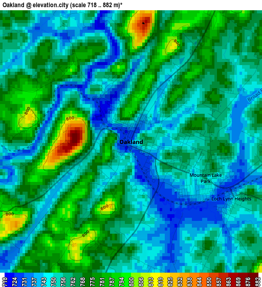
Below is the Elevation map of Oakland, which displays elevation range with different colors. Scale of the first map is from 718 to 882 m (2356 to 2894 ft) with average elevation of 761.2 meters (=2497 ft) [note 1]
These maps also provides idea of topography and contour of this city, they are displayed at different zoom levels. More info about maps, scale and edge coordinates you can find below images.
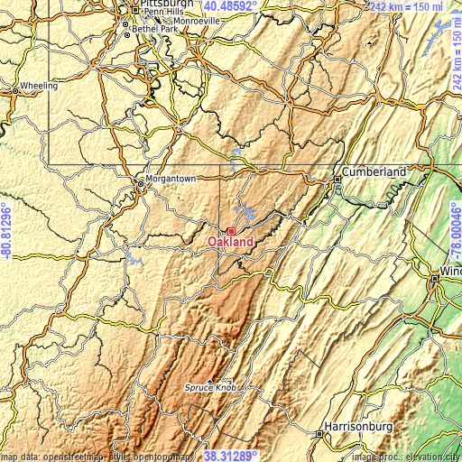
| \ | Map #1 | Topo.Map |
| Scale [m] | 718..882 m | × |
| Scale [ft] | 2356..2894 ft | × |
| Average | 761.2 m = 2497 ft | × |
| Width | 7.55 km = 4.7 mi | 241.6 km = 150.1 mi |
| Height | 7.55 km = 4.7 mi | 241.6 km = 150.1 mi |
| ↑Max Latitude | 39.441816° | 40.48592° |
| Latitude at center | 39.40787° | 39.40787° |
| ↓Min Latitude | 39.373908° | 38.31289° |
| ← Min Longitude | -79.450655° | -80.81296° |
| Longitude center | -79.40671° | -79.40671° |
| →Max Longitude | -79.362765° | -78.00046° |
Nearby cities:
Cities around Oakland sort by population:
• Frostburg elevation 629 m
49.6 km,  55°
55°
• Cheat Lake 300 m
48.3 km,  307°
307°
• Keyser 246 m
37.4 km,  84°
84°
• Brookhaven 317 m
48.3 km,  297°
297°
• Kingwood 556 m
24.8 km,  286°
286°
• Petersburg 285 m
52.2 km,  152°
152°
• Mountain Lake Park 749 m
2.4 km,  116°
116°
• Westernport 278 m
32.3 km,  74°
74°
• Terra Alta 786 m
12.7 km, 289°
• Parsons 501 m
41.9 km,  214°
214°
• Bel Air 212 m
51.2 km, 68°
• Lonaconing 457 m
40.6 km, 64°
Multilingual:
 En español:
Oakland elevación 738 m.
 En France:
Oakland élévation 738 m.


Sources and notes:
- [note 1] Map square and city borders are not equal. Map elevation data is calculated only from area inside that square.
- [src 1] Elevation data from geonames database provided with same terms of usage.
- [src 2] The elevation map of Oakland is generated using elevation data from NASA's 3 arcsec (90m) resolution SRTM data.
- [src 3] Base (background) map © OpenStreetMap contributors tiles are generated by Geofabrik and OpenTopoMap.
Copyright & License:
This Oakland Elevation Map is licensed under CC BY-SA. You may reuse any part from this page, if you give a proper credit by linking to this URL:
 More info on terms of use page.