Brookhaven elevation
Brookhaven (West Virginia, Monongalia County), United States elevation is 317 meters and Brookhaven elevation in feet is 1040 ft above sea level [src 1]. Brookhaven is a populated place (feature code) with elevation that is 38 meters (125 ft) bigger than average city elevation in United States.
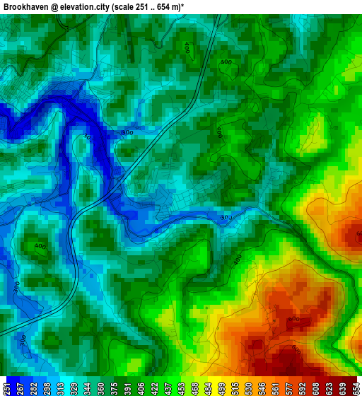
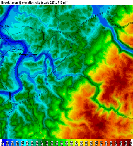
Below is the Elevation map of Brookhaven, which displays elevation range with different colors. Scale of the first map is from 251 to 654 m (823 to 2146 ft) with average elevation of 389.3 meters (=1277 ft) [note 1]
These maps also provides idea of topography and contour of this city, they are displayed at different zoom levels. More info about maps, scale and edge coordinates you can find below images.
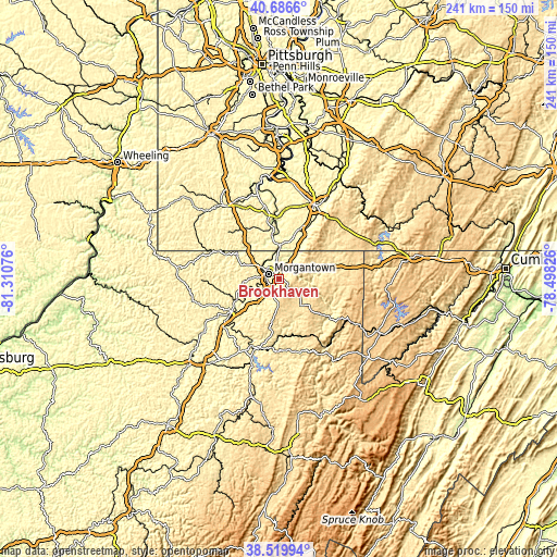
| \ | Map #1 | Map #2 | Topo.Map |
| Scale [m] | 251..654 m | 227..713 m | × |
| Scale [ft] | 823..2146 ft | 745..2339 ft | × |
| Average | 389.3 m = 1277 ft | 422.5 m = 1386 ft | × |
| Width | 7.53 km = 4.7 mi | 15.06 km = 9.4 mi | 240.9 km = 149.7 mi |
| Height | 7.53 km = 4.7 mi | 15.06 km = 9.4 mi | 240.9 km = 149.7 mi |
| ↑Max Latitude | 39.645596° | 39.679426° | 40.6866° |
| Latitude at center | 39.61175° | 39.61175° | 39.61175° |
| ↓Min Latitude | 39.577887° | 39.544007° | 38.51994° |
| ← Min Longitude | -79.948455° | -79.992401° | -81.31076° |
| Longitude center | -79.90451° | -79.90451° | -79.90451° |
| →Max Longitude | -79.860565° | -79.816619° | -78.49826° |
Nearby cities:
Cities around Brookhaven sort by population:
• Morgantown elevation 275 m
4.8 km,  294°
294°
• Fairmont 302 m
24.8 km,  235°
235°
• Cheat Lake 300 m
8 km,  33°
33°
• Westover 285 m
6.1 km, 294°
• Masontown 315 m
26.1 km,  0°
0°
• Pleasant Valley 314 m
26.8 km,  229°
229°
• Kingwood 556 m
24.5 km,  129°
129°
• Granville 246 m
8 km,  298°
298°
• Star City 286 m
8.7 km,  306°
306°
• Fairchance 334 m
26.9 km, 28°
• Barrackville 291 m
25.5 km, 241°
• Point Marion 253 m
14.2 km, 2°
Multilingual:
 En español:
Brookhaven elevación 317 m.
 En France:
Brookhaven élévation 317 m.
 Auf Deutsch:
Brookhaven höhe über dem Meeresspiegel ist 317 m.

Sources and notes:
- [note 1] Map square and city borders are not equal. Map elevation data is calculated only from area inside that square.
- [src 1] Elevation data from geonames database provided with same terms of usage.
- [src 2] The elevation map of Brookhaven is generated using elevation data from NASA's 3 arcsec (90m) resolution SRTM data.
- [src 3] Base (background) map © OpenStreetMap contributors tiles are generated by Geofabrik and OpenTopoMap.
Copyright & License:
This Brookhaven Elevation Map is licensed under CC BY-SA. You may reuse any part from this page, if you give a proper credit by linking to this URL:
 More info on terms of use page.