Mount Airy elevation
Mount Airy (Maryland, Carroll County), United States elevation is 235 meters and Mount Airy elevation in feet is 771 ft above sea level [src 1]. Mount Airy is a populated place (feature code) with elevation that is 44 meters (144 ft) smaller than average city elevation in United States.
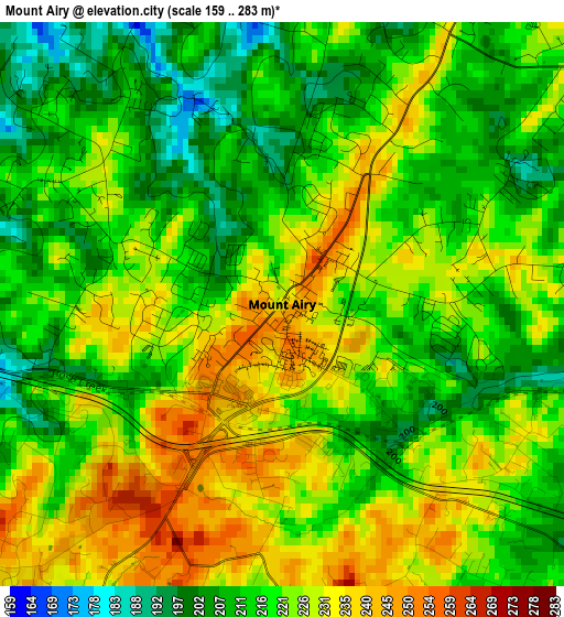
Below is the Elevation map of Mount Airy, which displays elevation range with different colors. Scale of the first map is from 159 to 283 m (522 to 928 ft) with average elevation of 220.4 meters (=723 ft) [note 1]
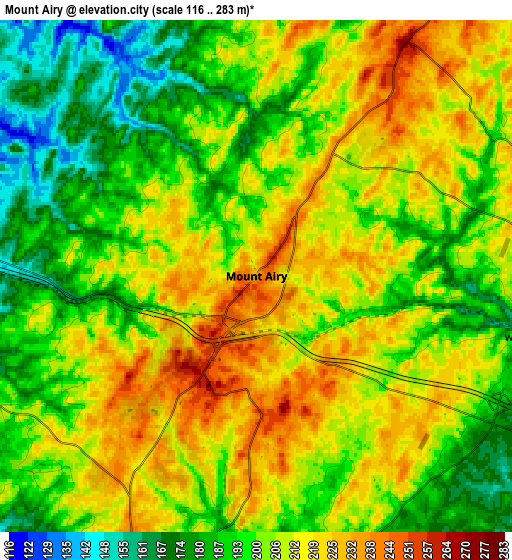
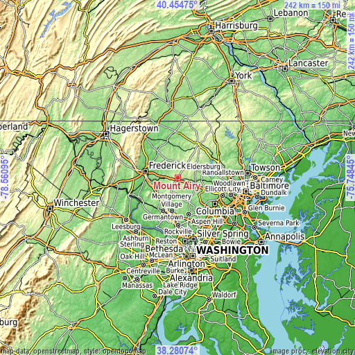
These maps also provides idea of topography and contour of this city, they are displayed at different zoom levels. More info about maps, scale and edge coordinates you can find below images.
| \ | Map #1 | Map #2 | Topo.Map |
| Scale [m] | 159..283 m | 116..283 m | × |
| Scale [ft] | 522..928 ft | 381..928 ft | × |
| Average | 220.4 m = 723 ft | 203.7 m = 668 ft | × |
| Width | 7.55 km = 4.7 mi | 15.11 km = 9.4 mi | 241.7 km = 150.2 mi |
| Height | 7.55 km = 4.7 mi | 15.11 km = 9.4 mi | 241.7 km = 150.2 mi |
| ↑Max Latitude | 39.410171° | 39.444116° | 40.45475° |
| Latitude at center | 39.37621° | 39.37621° | 39.37621° |
| ↓Min Latitude | 39.342232° | 39.308238° | 38.28074° |
| ← Min Longitude | -77.198645° | -77.242591° | -78.56095° |
| Longitude center | -77.1547° | -77.1547° | -77.1547° |
| →Max Longitude | -77.110755° | -77.066809° | -75.74845° |
Nearby cities:
Cities around Mount Airy sort by population:
• Eldersburg elevation 197 m
17.8 km,  80°
80°
• Damascus 256 m
10.6 km,  203°
203°
• Clarksburg 206 m
18.7 km,  215°
215°
• Green Valley 120 m
14.3 km,  238°
238°
• Urbana 141 m
17.8 km,  251°
251°
• Linganore 126 m
8.5 km,  327°
327°
• Walkersville 97 m
20.9 km,  305°
305°
• Spring Ridge 111 m
17.2 km,  279°
279°
• Sykesville 164 m
16.1 km,  90°
90°
• Bartonsville 124 m
17.6 km, 275°
• New Windsor 143 m
18.9 km,  12°
12°
• Woodsboro 114 m
22.2 km,  321°
321°
Multilingual:
 En español:
Mount Airy elevación 235 m.
 En France:
Mount Airy élévation 235 m.
 Auf Deutsch:
Mount Airy höhe über dem Meeresspiegel ist 235 m.

Sources and notes:
- [note 1] Map square and city borders are not equal. Map elevation data is calculated only from area inside that square.
- [src 1] Elevation data from geonames database provided with same terms of usage.
- [src 2] The elevation map of Mount Airy is generated using elevation data from NASA's 3 arcsec (90m) resolution SRTM data.
- [src 3] Base (background) map © OpenStreetMap contributors tiles are generated by Geofabrik and OpenTopoMap.
Copyright & License:
This Mount Airy Elevation Map is licensed under CC BY-SA. You may reuse any part from this page, if you give a proper credit by linking to this URL:
 More info on terms of use page.