Mitchellville elevation
Mitchellville (Maryland, Prince George's County), United States elevation is 36 meters and Mitchellville elevation in feet is 118 ft above sea level [src 1]. Mitchellville is a populated place (feature code) with elevation that is 243 meters (797 ft) smaller than average city elevation in United States.
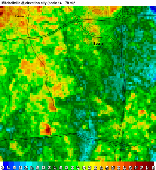
Below is the Elevation map of Mitchellville, which displays elevation range with different colors. Scale of the first map is from 14 to 79 m (46 to 259 ft) with average elevation of 42 meters (=138 ft) [note 1]
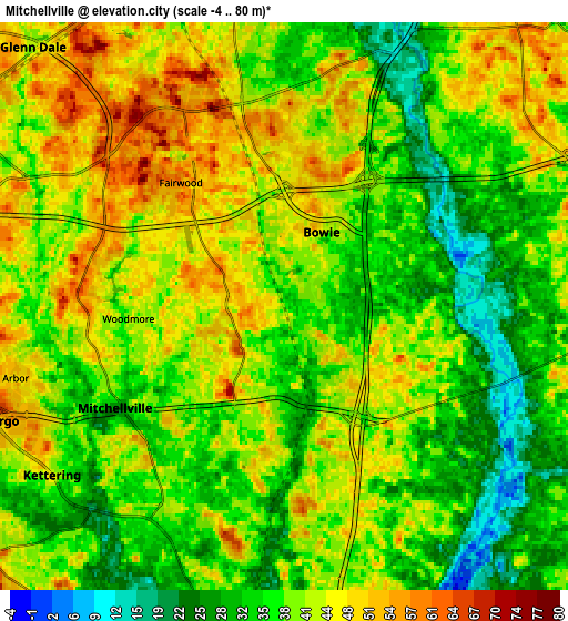
These maps also provides idea of topography and contour of this city, they are displayed at different zoom levels. More info about maps, scale and edge coordinates you can find below images.
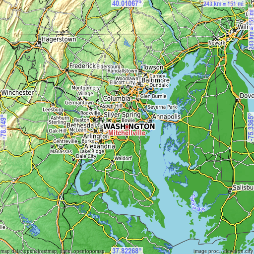
| \ | Map #1 | Map #2 | Topo.Map |
| Scale [m] | 14..79 m | -4..80 m | × |
| Scale [ft] | 46..259 ft | -13..262 ft | × |
| Average | 42 m = 138 ft | 39.6 m = 130 ft | × |
| Width | 7.6 km = 4.7 mi | 15.21 km = 9.5 mi | 243.3 km = 151.2 mi |
| Height | 7.6 km = 4.7 mi | 15.21 km = 9.5 mi | 243.3 km = 151.2 mi |
| ↑Max Latitude | 38.95929° | 38.993453° | 40.01067° |
| Latitude at center | 38.92511° | 38.92511° | 38.92511° |
| ↓Min Latitude | 38.890914° | 38.856701° | 37.82268° |
| ← Min Longitude | -76.786695° | -76.830641° | -78.149° |
| Longitude center | -76.74275° | -76.74275° | -76.74275° |
| →Max Longitude | -76.698805° | -76.654859° | -75.3365° |
Nearby cities:
Cities around Mitchellville sort by population:
• Bowie elevation 43 m
2.2 km,  28°
28°
• Crofton 36 m
9.8 km, 29°
• Glenn Dale 42 m
9.7 km,  315°
315°
• Kettering 47 m
7.7 km,  234°
234°
• Largo 53 m
8.2 km,  248°
248°
• Lake Arbor 50 m
7.8 km,  255°
255°
• Brock Hall 37 m
8.5 km,  190°
190°
• Davidsonville 51 m
9.9 km,  91°
91°
• Fairwood 54 m
4.6 km, 319°
• Woodmore 52 m
5.2 km,  265°
265°
• Springdale 38 m
8.4 km,  279°
279°
• Queen Anne 18 m
6.3 km,  117°
117°
Multilingual:
 En español:
Mitchellville elevación 36 m.
 En France:
Mitchellville élévation 36 m.
 Auf Deutsch:
Mitchellville höhe über dem Meeresspiegel ist 36 m.

Sources and notes:
- [note 1] Map square and city borders are not equal. Map elevation data is calculated only from area inside that square.
- [src 1] Elevation data from geonames database provided with same terms of usage.
- [src 2] The elevation map of Mitchellville is generated using elevation data from NASA's 3 arcsec (90m) resolution SRTM data.
- [src 3] Base (background) map © OpenStreetMap contributors tiles are generated by Geofabrik and OpenTopoMap.
Copyright & License:
This Mitchellville Elevation Map is licensed under CC BY-SA. You may reuse any part from this page, if you give a proper credit by linking to this URL:
 More info on terms of use page.