Crofton elevation
Crofton (Maryland, Anne Arundel County), United States elevation is 36 meters and Crofton elevation in feet is 118 ft above sea level [src 1]. Crofton is a populated place (feature code) with elevation that is 243 meters (797 ft) smaller than average city elevation in United States.
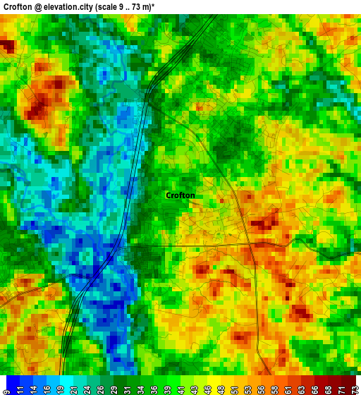
Below is the Elevation map of Crofton, which displays elevation range with different colors. Scale of the first map is from 9 to 73 m (30 to 240 ft) with average elevation of 38.3 meters (=126 ft) [note 1]
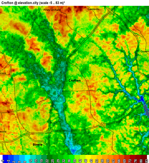
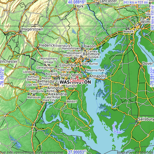
These maps also provides idea of topography and contour of this city, they are displayed at different zoom levels. More info about maps, scale and edge coordinates you can find below images.
| \ | Map #1 | Map #2 | Topo.Map |
| Scale [m] | 9..73 m | -5..83 m | × |
| Scale [ft] | 30..240 ft | -16..272 ft | × |
| Average | 38.3 m = 126 ft | 39.8 m = 131 ft | × |
| Width | 7.59 km = 4.7 mi | 15.19 km = 9.4 mi | 243 km = 151 mi |
| Height | 7.59 km = 4.7 mi | 15.19 km = 9.4 mi | 243 km = 151 mi |
| ↑Max Latitude | 39.035923° | 39.070049° | 40.08615° |
| Latitude at center | 39.00178° | 39.00178° | 39.00178° |
| ↓Min Latitude | 38.967621° | 38.933445° | 37.90053° |
| ← Min Longitude | -76.731415° | -76.775361° | -78.09372° |
| Longitude center | -76.68747° | -76.68747° | -76.68747° |
| →Max Longitude | -76.643525° | -76.599579° | -75.28122° |
Nearby cities:
Cities around Crofton sort by population:
• Bowie elevation 43 m
7.5 km,  209°
209°
• Odenton 47 m
9.2 km,  353°
353°
• Glenn Dale 42 m
11.6 km,  262°
262°
• Mitchellville 36 m
9.8 km, 209°
• Davidsonville 51 m
10.2 km,  149°
149°
• Fairwood 54 m
9.3 km,  237°
237°
• Riva 16 m
11 km,  120°
120°
• Gambrills 47 m
7.5 km,  14°
14°
• Herald Harbor 21 m
11.7 km,  60°
60°
• Arden on the Severn 22 m
11.8 km,  52°
52°
• Crownsville 40 m
8 km,  68°
68°
• Queen Anne 18 m
11.5 km,  176°
176°
Multilingual:
 En español:
Crofton elevación 36 m.
 En France:
Crofton élévation 36 m.


Sources and notes:
- [note 1] Map square and city borders are not equal. Map elevation data is calculated only from area inside that square.
- [src 1] Elevation data from geonames database provided with same terms of usage.
- [src 2] The elevation map of Crofton is generated using elevation data from NASA's 3 arcsec (90m) resolution SRTM data.
- [src 3] Base (background) map © OpenStreetMap contributors tiles are generated by Geofabrik and OpenTopoMap.
Copyright & License:
This Crofton Elevation Map is licensed under CC BY-SA. You may reuse any part from this page, if you give a proper credit by linking to this URL:
 More info on terms of use page.