Hampstead elevation
Hampstead (Maryland, Carroll County), United States elevation is 278 meters and Hampstead elevation in feet is 912 ft above sea level [src 1]. Hampstead is a populated place (feature code) with elevation that is 1 meters (3 ft) smaller than average city elevation in United States.
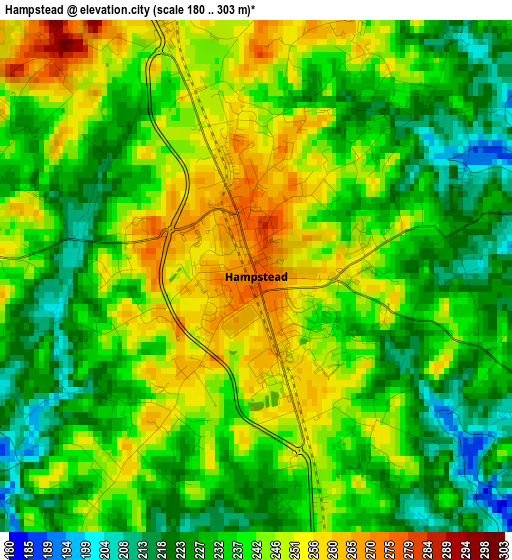
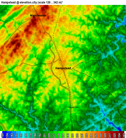
Below is the Elevation map of Hampstead, which displays elevation range with different colors. Scale of the first map is from 180 to 303 m (591 to 994 ft) with average elevation of 238.1 meters (=781 ft) [note 1]
These maps also provides idea of topography and contour of this city, they are displayed at different zoom levels. More info about maps, scale and edge coordinates you can find below images.
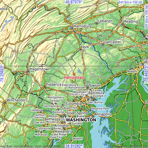
| \ | Map #1 | Map #2 | Topo.Map |
| Scale [m] | 180..303 m | 126..342 m | × |
| Scale [ft] | 591..994 ft | 413..1122 ft | × |
| Average | 238.1 m = 781 ft | 230.3 m = 756 ft | × |
| Width | 7.53 km = 4.7 mi | 15.06 km = 9.4 mi | 240.9 km = 149.7 mi |
| Height | 7.53 km = 4.7 mi | 15.06 km = 9.4 mi | 240.9 km = 149.7 mi |
| ↑Max Latitude | 39.63868° | 39.672513° | 40.67979° |
| Latitude at center | 39.60483° | 39.60483° | 39.60483° |
| ↓Min Latitude | 39.570964° | 39.537081° | 38.51292° |
| ← Min Longitude | -76.893925° | -76.937871° | -78.25623° |
| Longitude center | -76.84998° | -76.84998° | -76.84998° |
| →Max Longitude | -76.806035° | -76.762089° | -75.44373° |
Nearby cities:
Cities around Hampstead sort by population:
• Owings Mills elevation 152 m
21.5 km,  163°
163°
• Reisterstown 220 m
15.1 km,  174°
174°
• Hunt Valley 89 m
21.4 km,  123°
123°
• Cockeysville 91 m
22.4 km,  127°
127°
• Westminster 223 m
12.9 km,  255°
255°
• Garrison 136 m
23.4 km, 160°
• Parkville 235 m
21.9 km,  333°
333°
• Manchester 303 m
6.9 km, 334°
• New Freedom 252 m
19.5 km,  40°
40°
• Shrewsbury 299 m
23.3 km, 38°
• Glen Rock 170 m
23.3 km,  26°
26°
• New Windsor 143 m
23.2 km,  252°
252°
Multilingual:
 En español:
Hampstead elevación 278 m.
 En France:
Hampstead élévation 278 m.
 Auf Deutsch:
Hampstead höhe über dem Meeresspiegel ist 278 m.

Sources and notes:
- [note 1] Map square and city borders are not equal. Map elevation data is calculated only from area inside that square.
- [src 1] Elevation data from geonames database provided with same terms of usage.
- [src 2] The elevation map of Hampstead is generated using elevation data from NASA's 3 arcsec (90m) resolution SRTM data.
- [src 3] Base (background) map © OpenStreetMap contributors tiles are generated by Geofabrik and OpenTopoMap.
Copyright & License:
This Hampstead Elevation Map is licensed under CC BY-SA. You may reuse any part from this page, if you give a proper credit by linking to this URL:
 More info on terms of use page.