Columbia elevation
Columbia (Maryland, Howard County), United States elevation is 122 meters and Columbia elevation in feet is 400 ft above sea level [src 1]. Columbia is a populated place (feature code) with elevation that is 157 meters (515 ft) smaller than average city elevation in United States.
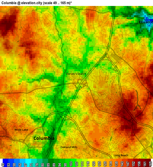
Below is the Elevation map of Columbia, which displays elevation range with different colors. Scale of the first map is from 49 to 165 m (161 to 541 ft) with average elevation of 123.4 meters (=405 ft) [note 1]
These maps also provides idea of topography and contour of this city, they are displayed at different zoom levels. More info about maps, scale and edge coordinates you can find below images.
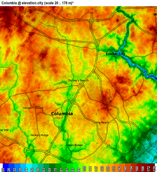
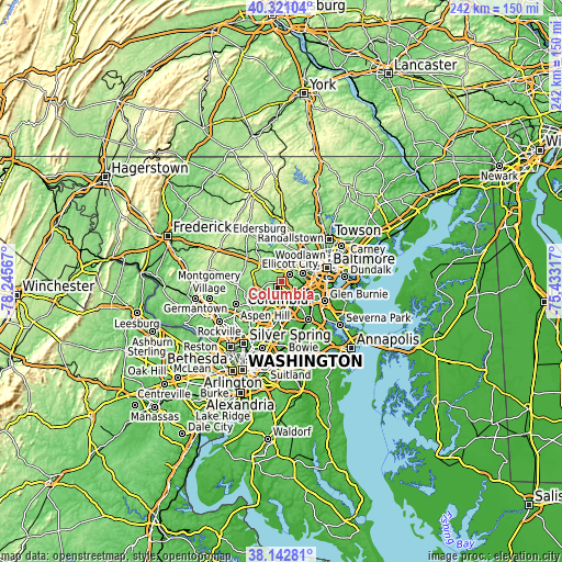
| \ | Map #1 | Map #2 | Topo.Map |
| Scale [m] | 49..165 m | 20..178 m | × |
| Scale [ft] | 161..541 ft | 66..584 ft | × |
| Average | 123.4 m = 405 ft | 120.5 m = 395 ft | × |
| Width | 7.57 km = 4.7 mi | 15.14 km = 9.4 mi | 242.2 km = 150.5 mi |
| Height | 7.57 km = 4.7 mi | 15.14 km = 9.4 mi | 242.2 km = 150.5 mi |
| ↑Max Latitude | 39.274407° | 39.308418° | 40.32104° |
| Latitude at center | 39.24038° | 39.24038° | 39.24038° |
| ↓Min Latitude | 39.206336° | 39.172276° | 38.14281° |
| ← Min Longitude | -76.883365° | -76.927311° | -78.24567° |
| Longitude center | -76.83942° | -76.83942° | -76.83942° |
| →Max Longitude | -76.795475° | -76.751529° | -75.43317° |
Nearby cities:
Cities around Columbia sort by population:
• Ellicott City elevation 55 m
4.6 km,  49°
49°
• Catonsville 146 m
9.9 km,  69°
69°
• Hanover 32 m
11.2 km,  118°
118°
• West Elkridge 70 m
10.4 km,  110°
110°
• Scaggsville 132 m
11.8 km,  206°
206°
• Ilchester 44 m
6.5 km,  79°
79°
• Elkridge 37 m
11.3 km, 105°
• Jessup 70 m
11.5 km,  151°
151°
• Savage 68 m
11.5 km,  173°
173°
• Riverside 100 m
8.4 km, 207°
• North Laurel 95 m
11.6 km,  193°
193°
• Charlestown 97 m
12 km, 75°
Multilingual:
 En español:
Columbia elevación 122 m.
 En France:
Columbia élévation 122 m.
 Auf Deutsch:
Columbia höhe über dem Meeresspiegel ist 122 m.

Sources and notes:
- [note 1] Map square and city borders are not equal. Map elevation data is calculated only from area inside that square.
- [src 1] Elevation data from geonames database provided with same terms of usage.
- [src 2] The elevation map of Columbia is generated using elevation data from NASA's 3 arcsec (90m) resolution SRTM data.
- [src 3] Base (background) map © OpenStreetMap contributors tiles are generated by Geofabrik and OpenTopoMap.
Copyright & License:
This Columbia Elevation Map is licensed under CC BY-SA. You may reuse any part from this page, if you give a proper credit by linking to this URL:
 More info on terms of use page.