Scaggsville elevation
Scaggsville (Maryland, Howard County), United States elevation is 132 meters and Scaggsville elevation in feet is 433 ft above sea level [src 1]. Scaggsville is a populated place (feature code) with elevation that is 147 meters (482 ft) smaller than average city elevation in United States.
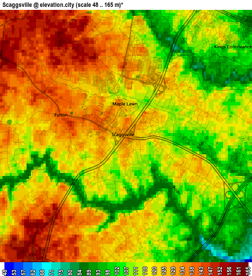
Below is the Elevation map of Scaggsville, which displays elevation range with different colors. Scale of the first map is from 48 to 165 m (157 to 541 ft) with average elevation of 119.4 meters (=392 ft) [note 1]
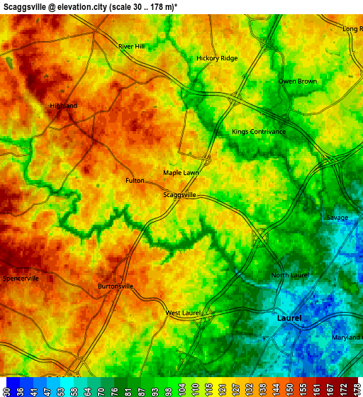
These maps also provides idea of topography and contour of this city, they are displayed at different zoom levels. More info about maps, scale and edge coordinates you can find below images.
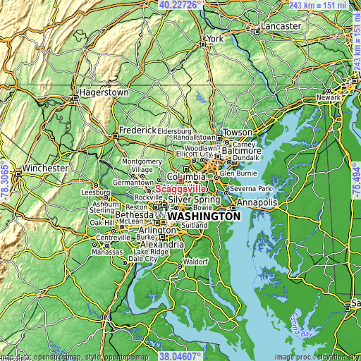
| \ | Map #1 | Map #2 | Topo.Map |
| Scale [m] | 48..165 m | 30..178 m | × |
| Scale [ft] | 157..541 ft | 98..584 ft | × |
| Average | 119.4 m = 392 ft | 113.4 m = 372 ft | × |
| Width | 7.58 km = 4.7 mi | 15.16 km = 9.4 mi | 242.5 km = 150.7 mi |
| Height | 7.58 km = 4.7 mi | 15.16 km = 9.4 mi | 242.5 km = 150.7 mi |
| ↑Max Latitude | 39.179184° | 39.213241° | 40.22726° |
| Latitude at center | 39.14511° | 39.14511° | 39.14511° |
| ↓Min Latitude | 39.11102° | 39.076913° | 38.04607° |
| ← Min Longitude | -76.944195° | -76.988141° | -78.3065° |
| Longitude center | -76.90025° | -76.90025° | -76.90025° |
| →Max Longitude | -76.856305° | -76.812359° | -75.494° |
Nearby cities:
Cities around Scaggsville sort by population:
• Laurel elevation 52 m
6.8 km,  138°
138°
• Fairland 126 m
9.1 km,  212°
212°
• Maryland City 69 m
9.2 km,  129°
129°
• Burtonsville 150 m
4.7 km,  216°
216°
• Savage 68 m
6.6 km,  96°
96°
• Riverside 100 m
3.4 km,  22°
22°
• Ashton-Sandy Spring 153 m
9.1 km,  273°
273°
• North Laurel 95 m
2.7 km, 104°
• West Laurel 115 m
4.9 km,  179°
179°
• Fulton 140 m
2.1 km,  288°
288°
• Spencerville 152 m
7.6 km,  243°
243°
• Highland 158 m
6.2 km,  307°
307°
Multilingual:
 En español:
Scaggsville elevación 132 m.
 En France:
Scaggsville élévation 132 m.
 Auf Deutsch:
Scaggsville höhe über dem Meeresspiegel ist 132 m.

Sources and notes:
- [note 1] Map square and city borders are not equal. Map elevation data is calculated only from area inside that square.
- [src 1] Elevation data from geonames database provided with same terms of usage.
- [src 2] The elevation map of Scaggsville is generated using elevation data from NASA's 3 arcsec (90m) resolution SRTM data.
- [src 3] Base (background) map © OpenStreetMap contributors tiles are generated by Geofabrik and OpenTopoMap.
Copyright & License:
This Scaggsville Elevation Map is licensed under CC BY-SA. You may reuse any part from this page, if you give a proper credit by linking to this URL:
 More info on terms of use page.