Clinton elevation
Clinton (Louisiana, East Feliciana Parish), United States elevation is 69 meters and Clinton elevation in feet is 226 ft above sea level [src 1]. Clinton is a seat of a second-order administrative division (feature code) with elevation that is 210 meters (689 ft) smaller than average city elevation in United States.
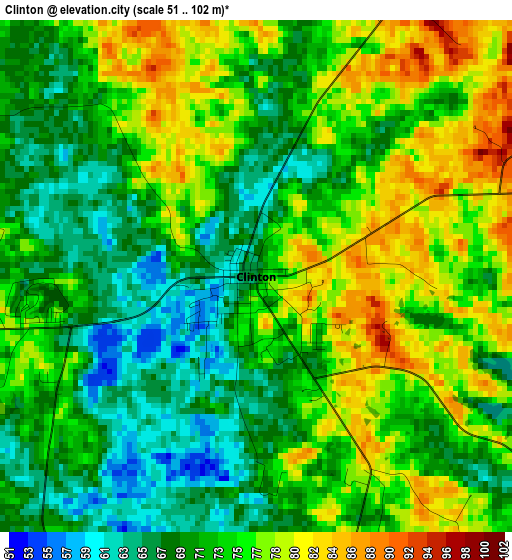
Below is the Elevation map of Clinton, which displays elevation range with different colors. Scale of the first map is from 51 to 102 m (167 to 335 ft) with average elevation of 72.8 meters (=239 ft) [note 1]
These maps also provides idea of topography and contour of this city, they are displayed at different zoom levels. More info about maps, scale and edge coordinates you can find below images.
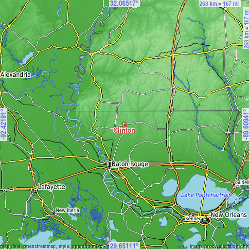
| \ | Map #1 | Topo.Map |
| Scale [m] | 51..102 m | × |
| Scale [ft] | 167..335 ft | × |
| Average | 72.8 m = 239 ft | × |
| Width | 8.39 km = 5.2 mi | 268.4 km = 166.8 mi |
| Height | 8.39 km = 5.2 mi | 268.4 km = 166.8 mi |
| ↑Max Latitude | 30.903454° | 32.06517° |
| Latitude at center | 30.86574° | 30.86574° |
| ↓Min Latitude | 30.828011° | 29.65111° |
| ← Min Longitude | -91.059605° | -92.42191° |
| Longitude center | -91.01566° | -91.01566° |
| →Max Longitude | -90.971715° | -89.60941° |
Nearby cities:
Cities around Clinton sort by population:
• Central elevation 25 m
34.7 km,  183°
183°
• Zachary 34 m
27.6 km,  209°
209°
• Baker 28 m
34.1 km, 205°
• Brownsfield 22 m
36.9 km,  195°
195°
• Jackson 50 m
19.5 km,  260°
260°
• Greenwood 22 m
36.7 km,  193°
193°
• Saint Francisville 38 m
35.8 km,  254°
254°
• Centreville 119 m
25.4 km,  348°
348°
• Watson 24 m
32.8 km,  169°
169°
• Woodville 126 m
37.9 km,  314°
314°
• Liberty 112 m
37.9 km,  30°
30°
• Greensburg 73 m
33.1 km,  96°
96°
Multilingual:
 En español:
Clinton elevación 69 m.
 En France:
Clinton élévation 69 m.


Sources and notes:
- [note 1] Map square and city borders are not equal. Map elevation data is calculated only from area inside that square.
- [src 1] Elevation data from geonames database provided with same terms of usage.
- [src 2] The elevation map of Clinton is generated using elevation data from NASA's 3 arcsec (90m) resolution SRTM data.
- [src 3] Base (background) map © OpenStreetMap contributors tiles are generated by Geofabrik and OpenTopoMap.
Copyright & License:
This Clinton Elevation Map is licensed under CC BY-SA. You may reuse any part from this page, if you give a proper credit by linking to this URL:
 More info on terms of use page.