Arcadia elevation
Arcadia (Louisiana, Bienville Parish), United States elevation is 122 meters and Arcadia elevation in feet is 400 ft above sea level [src 1]. Arcadia is a seat of a second-order administrative division (feature code) with elevation that is 157 meters (515 ft) smaller than average city elevation in United States.
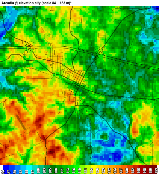
Below is the Elevation map of Arcadia, which displays elevation range with different colors. Scale of the first map is from 84 to 153 m (276 to 502 ft) with average elevation of 115.2 meters (=378 ft) [note 1]
These maps also provides idea of topography and contour of this city, they are displayed at different zoom levels. More info about maps, scale and edge coordinates you can find below images.
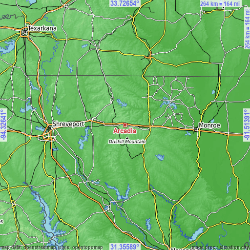
| \ | Map #1 | Topo.Map |
| Scale [m] | 84..153 m | × |
| Scale [ft] | 276..502 ft | × |
| Average | 115.2 m = 378 ft | × |
| Width | 8.24 km = 5.1 mi | 263.6 km = 163.8 mi |
| Height | 8.24 km = 5.1 mi | 263.6 km = 163.8 mi |
| ↑Max Latitude | 32.586075° | 33.72654° |
| Latitude at center | 32.54904° | 32.54904° |
| ↓Min Latitude | 32.511989° | 31.35589° |
| ← Min Longitude | -92.964105° | -94.32641° |
| Longitude center | -92.92016° | -92.92016° |
| →Max Longitude | -92.876215° | -91.51391° |
Nearby cities:
Cities around Arcadia sort by population:
• Ruston elevation 104 m
26.6 km,  96°
96°
• Minden 82 m
35.1 km,  282°
282°
• Grambling 98 m
19.5 km, 97°
• Jonesboro 72 m
39.2 km,  150°
150°
• Eastwood 76 m
60.6 km,  270°
270°
• Farmerville 56 m
54.2 km,  62°
62°
• Haughton 77 m
54.8 km, 268°
• Homer 72 m
29.8 km,  334°
334°
• Haynesville 114 m
50.3 km,  335°
335°
• Bernice 70 m
39 km,  38°
38°
• Ringgold 88 m
41.7 km,  234°
234°
• Sibley 68 m
35.3 km, 268°
Multilingual:
 En español:
Arcadia elevación 122 m.
 En France:
Arcadia élévation 122 m.


Sources and notes:
- [note 1] Map square and city borders are not equal. Map elevation data is calculated only from area inside that square.
- [src 1] Elevation data from geonames database provided with same terms of usage.
- [src 2] The elevation map of Arcadia is generated using elevation data from NASA's 3 arcsec (90m) resolution SRTM data.
- [src 3] Base (background) map © OpenStreetMap contributors tiles are generated by Geofabrik and OpenTopoMap.
Copyright & License:
This Arcadia Elevation Map is licensed under CC BY-SA. You may reuse any part from this page, if you give a proper credit by linking to this URL:
 More info on terms of use page.