Springfield elevation
Springfield (Kentucky, Washington County), United States elevation is 233 meters and Springfield elevation in feet is 764 ft above sea level [src 1]. Springfield is a seat of a second-order administrative division (feature code) with elevation that is 46 meters (151 ft) smaller than average city elevation in United States.
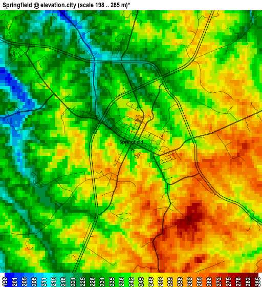
Below is the Elevation map of Springfield, which displays elevation range with different colors. Scale of the first map is from 198 to 285 m (650 to 935 ft) with average elevation of 242.8 meters (=797 ft) [note 1]
These maps also provides idea of topography and contour of this city, they are displayed at different zoom levels. More info about maps, scale and edge coordinates you can find below images.
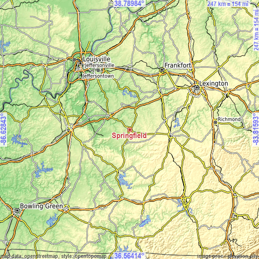
| \ | Map #1 | Topo.Map |
| Scale [m] | 198..285 m | × |
| Scale [ft] | 650..935 ft | × |
| Average | 242.8 m = 797 ft | × |
| Width | 7.73 km = 4.8 mi | 247.5 km = 153.8 mi |
| Height | 7.73 km = 4.8 mi | 247.5 km = 153.8 mi |
| ↑Max Latitude | 37.720109° | 38.78984° |
| Latitude at center | 37.68534° | 37.68534° |
| ↓Min Latitude | 37.650554° | 36.56414° |
| ← Min Longitude | -85.266125° | -86.62843° |
| Longitude center | -85.22218° | -85.22218° |
| →Max Longitude | -85.178235° | -83.81593° |
Nearby cities:
Cities around Springfield sort by population:
• Danville elevation 305 m
39.9 km,  96°
96°
• Bardstown 201 m
25.5 km,  302°
302°
• Campbellsville 250 m
39.5 km,  195°
195°
• Harrodsburg 260 m
34.4 km,  75°
75°
• Lebanon 241 m
13.1 km,  191°
191°
• Hodgenville 222 m
47.2 km,  254°
254°
• Jackson 262 m
34.6 km,  63°
63°
• Junction City 302 m
39.3 km,  106°
106°
• Liberty 248 m
47.8 km,  148°
148°
• Lebanon Junction 141 m
47.8 km,  290°
290°
• Bloomfield 211 m
26.4 km,  341°
341°
• Taylorsville 149 m
39.9 km, 344°
Multilingual:
 En español:
Springfield elevación 233 m.
 En France:
Springfield élévation 233 m.
 Auf Deutsch:
Springfield höhe über dem Meeresspiegel ist 233 m.

Sources and notes:
- [note 1] Map square and city borders are not equal. Map elevation data is calculated only from area inside that square.
- [src 1] Elevation data from geonames database provided with same terms of usage.
- [src 2] The elevation map of Springfield is generated using elevation data from NASA's 3 arcsec (90m) resolution SRTM data.
- [src 3] Base (background) map © OpenStreetMap contributors tiles are generated by Geofabrik and OpenTopoMap.
Copyright & License:
This Springfield Elevation Map is licensed under CC BY-SA. You may reuse any part from this page, if you give a proper credit by linking to this URL:
 More info on terms of use page.