Middlesboro elevation
Middlesboro (Kentucky, Bell County), United States elevation is 352 meters and Middlesboro elevation in feet is 1155 ft above sea level [src 1]. Middlesboro is a populated place (feature code) with elevation that is 73 meters (240 ft) bigger than average city elevation in United States.
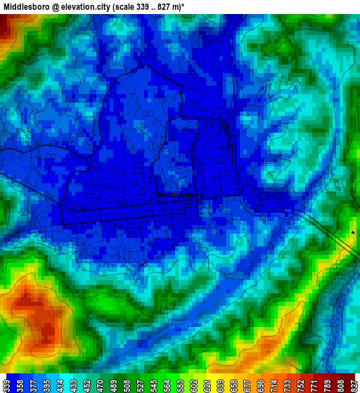
Below is the Elevation map of Middlesboro, which displays elevation range with different colors. Scale of the first map is from 339 to 827 m (1112 to 2713 ft) with average elevation of 436.8 meters (=1433 ft) [note 1]
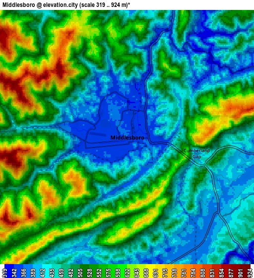
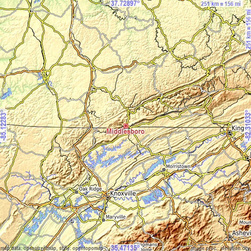
These maps also provides idea of topography and contour of this city, they are displayed at different zoom levels. More info about maps, scale and edge coordinates you can find below images.
| \ | Map #1 | Map #2 | Topo.Map |
| Scale [m] | 339..827 m | 319..924 m | × |
| Scale [ft] | 1112..2713 ft | 1047..3031 ft | × |
| Average | 436.8 m = 1433 ft | 504.6 m = 1656 ft | × |
| Width | 7.84 km = 4.9 mi | 15.69 km = 9.7 mi | 251 km = 156 mi |
| Height | 7.84 km = 4.9 mi | 15.69 km = 9.7 mi | 251 km = 156 mi |
| ↑Max Latitude | 36.643688° | 36.67894° | 37.72897° |
| Latitude at center | 36.60842° | 36.60842° | 36.60842° |
| ↓Min Latitude | 36.573136° | 36.537835° | 35.47135° |
| ← Min Longitude | -83.760525° | -83.804471° | -85.12283° |
| Longitude center | -83.71658° | -83.71658° | -83.71658° |
| →Max Longitude | -83.672635° | -83.628689° | -82.31033° |
Nearby cities:
Cities around Middlesboro sort by population:
• LaFollette elevation 325 m
43.9 km,  235°
235°
• Williamsburg 285 m
42.3 km,  290°
290°
• Harrogate 403 m
6.1 km,  118°
118°
• Barbourville 301 m
32.5 km,  331°
331°
• New Tazewell 450 m
21.2 km,  150°
150°
• Maynardville 372 m
40.4 km,  190°
190°
• Tazewell 417 m
21.6 km,  142°
142°
• Jellico 304 m
36.7 km,  266°
266°
• Pineville 310 m
17.2 km,  6°
6°
• Harlan 363 m
43.8 km,  53°
53°
• Fincastle 347 m
36.9 km,  233°
233°
• Rutledge 309 m
40.6 km, 153°
Multilingual:
 En español:
Middlesboro elevación 352 m.
 En France:
Middlesboro élévation 352 m.
 Auf Deutsch:
Middlesboro höhe über dem Meeresspiegel ist 352 m.

Sources and notes:
- [note 1] Map square and city borders are not equal. Map elevation data is calculated only from area inside that square.
- [src 1] Elevation data from geonames database provided with same terms of usage.
- [src 2] The elevation map of Middlesboro is generated using elevation data from NASA's 3 arcsec (90m) resolution SRTM data.
- [src 3] Base (background) map © OpenStreetMap contributors tiles are generated by Geofabrik and OpenTopoMap.
Copyright & License:
This Middlesboro Elevation Map is licensed under CC BY-SA. You may reuse any part from this page, if you give a proper credit by linking to this URL:
 More info on terms of use page.