LaFollette elevation
LaFollette (Tennessee, Campbell County), United States elevation is 325 meters and LaFollette elevation in feet is 1066 ft above sea level [src 1]. LaFollette is a populated place (feature code) with elevation that is 46 meters (151 ft) bigger than average city elevation in United States.
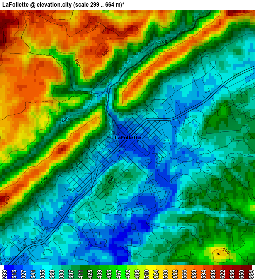
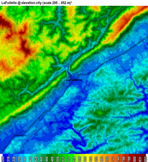
Below is the Elevation map of LaFollette, which displays elevation range with different colors. Scale of the first map is from 299 to 664 m (981 to 2178 ft) with average elevation of 431.1 meters (=1414 ft) [note 1]
These maps also provides idea of topography and contour of this city, they are displayed at different zoom levels. More info about maps, scale and edge coordinates you can find below images.
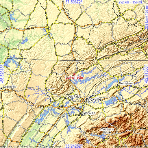
| \ | Map #1 | Map #2 | Topo.Map |
| Scale [m] | 299..664 m | 295..852 m | × |
| Scale [ft] | 981..2178 ft | 968..2795 ft | × |
| Average | 431.1 m = 1414 ft | 460.8 m = 1512 ft | × |
| Width | 7.87 km = 4.9 mi | 15.74 km = 9.8 mi | 251.8 km = 156.5 mi |
| Height | 7.87 km = 4.9 mi | 15.74 km = 9.8 mi | 251.8 km = 156.5 mi |
| ↑Max Latitude | 36.418231° | 36.453586° | 37.50672° |
| Latitude at center | 36.38286° | 36.38286° | 36.38286° |
| ↓Min Latitude | 36.347473° | 36.31207° | 35.24252° |
| ← Min Longitude | -84.163875° | -84.207821° | -85.52618° |
| Longitude center | -84.11993° | -84.11993° | -84.11993° |
| →Max Longitude | -84.075985° | -84.032039° | -82.71368° |
Nearby cities:
Cities around LaFollette sort by population:
• Clinton elevation 253 m
31.1 km,  181°
181°
• Pine Crest 393 m
11.9 km, 183°
• Maynardville 372 m
32.4 km,  116°
116°
• Jellico 304 m
22.8 km,  358°
358°
• Caryville 335 m
13.1 km,  224°
224°
• Jacksboro 327 m
8.2 km, 224°
• Condon 346 m
36.8 km,  127°
127°
• Rocky Top 266 m
18.6 km,  189°
189°
• Hunter 334 m
2.9 km, 218°
• Norris 333 m
21.3 km,  167°
167°
• Fincastle 347 m
7.1 km,  65°
65°
• Huntsville 404 m
33.3 km,  275°
275°
Multilingual:
 En español:
LaFollette elevación 325 m.
 En France:
LaFollette élévation 325 m.
 Auf Deutsch:
LaFollette höhe über dem Meeresspiegel ist 325 m.

Sources and notes:
- [note 1] Map square and city borders are not equal. Map elevation data is calculated only from area inside that square.
- [src 1] Elevation data from geonames database provided with same terms of usage.
- [src 2] The elevation map of LaFollette is generated using elevation data from NASA's 3 arcsec (90m) resolution SRTM data.
- [src 3] Base (background) map © OpenStreetMap contributors tiles are generated by Geofabrik and OpenTopoMap.
Copyright & License:
This LaFollette Elevation Map is licensed under CC BY-SA. You may reuse any part from this page, if you give a proper credit by linking to this URL:
 More info on terms of use page.