McKee elevation
McKee (Kentucky, Jackson County), United States elevation is 315 meters and McKee elevation in feet is 1033 ft above sea level [src 1]. McKee is a seat of a second-order administrative division (feature code) with elevation that is 36 meters (118 ft) bigger than average city elevation in United States.
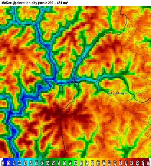
Below is the Elevation map of McKee, which displays elevation range with different colors. Scale of the first map is from 299 to 451 m (981 to 1480 ft) with average elevation of 393.2 meters (=1290 ft) [note 1]
These maps also provides idea of topography and contour of this city, they are displayed at different zoom levels. More info about maps, scale and edge coordinates you can find below images.
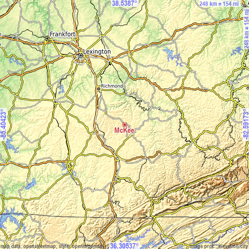
| \ | Map #1 | Topo.Map |
| Scale [m] | 299..451 m | × |
| Scale [ft] | 981..1480 ft | × |
| Average | 393.2 m = 1290 ft | × |
| Width | 7.76 km = 4.8 mi | 248.3 km = 154.3 mi |
| Height | 7.76 km = 4.8 mi | 248.3 km = 154.3 mi |
| ↑Max Latitude | 37.465249° | 38.5387° |
| Latitude at center | 37.43036° | 37.43036° |
| ↓Min Latitude | 37.395455° | 36.30537° |
| ← Min Longitude | -84.041925° | -85.40423° |
| Longitude center | -83.99798° | -83.99798° |
| →Max Longitude | -83.954035° | -82.59173° |
Nearby cities:
Cities around McKee sort by population:
• Richmond elevation 293 m
43.9 km,  323°
323°
• Berea 314 m
30.5 km,  300°
300°
• London 379 m
34.3 km,  192°
192°
• Stanton 206 m
47.8 km,  14°
14°
• Mount Vernon 368 m
31.5 km,  254°
254°
• Irvine 208 m
30.1 km,  4°
4°
• Manchester 278 m
37.2 km,  145°
145°
• Beattyville 203 m
30.1 km,  58°
58°
• Brodhead 289 m
36.8 km,  265°
265°
• Clay City 192 m
48.2 km, 8°
• Annville 339 m
12.6 km,  168°
168°
• Booneville 214 m
29 km,  79°
79°
Multilingual:
 En español:
McKee elevación 315 m.
 En France:
McKee élévation 315 m.


Sources and notes:
- [note 1] Map square and city borders are not equal. Map elevation data is calculated only from area inside that square.
- [src 1] Elevation data from geonames database provided with same terms of usage.
- [src 2] The elevation map of McKee is generated using elevation data from NASA's 3 arcsec (90m) resolution SRTM data.
- [src 3] Base (background) map © OpenStreetMap contributors tiles are generated by Geofabrik and OpenTopoMap.
Copyright & License:
This McKee Elevation Map is licensed under CC BY-SA. You may reuse any part from this page, if you give a proper credit by linking to this URL:
 More info on terms of use page.